| Mesoscale Discussion 162 | |
| < Previous MD | |

|
|
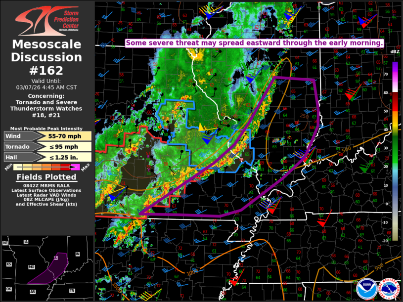
   Mesoscale Discussion 0162
   NWS Storm Prediction Center Norman OK
   0244 AM CST Sat Mar 07 2026

   Areas affected...Southeast MO into southern IL

   Concerning...Tornado and Severe Thunderstorm Watches 18...21...

   Valid 070844Z - 071045Z

   The severe weather threat for Tornado and Severe Thunderstorm
   Watches 18, 21 continues.

   SUMMARY...Some severe threat may spread eastward through the early
   morning.

   DISCUSSION...Despite the presence of favorable low-level moisture
   (with dewpoints in the low 60s F) and very strong low-level flow
   (with 60+ kt at 1-2 km AGL noted in regional VWPs), ongoing
   convection remains generally disorganized early this morning across
   parts of southern IL/MO. This is likely due to weak lapse
   rates/buoyancy and an undercutting outflow that is generally
   parallel to the deep-layer flow. However, buoyancy may modestly
   improve with time due to continued low-level moisture transport
   within the seasonably warm boundary layer. Locally damaging gusts
   and/or a brief tornado remain possible if there is any increase in
   convective organization early this morning. This conditional threat
   may be realized if any part of the ongoing convective line can take
   on a more north-south orientation, or if any of the ongoing discrete
   convection in advance of the line can intensify before merging into
   the QLCS.

   Given the weak buoyancy and current disorganized state of the
   ongoing QLCS, downstream watch issuance is unlikely in the short
   term. However, trends will continue to be monitored for any uptick
   in storm organization, given the presence of very strong low-level
   flow/shear across the region.

   ..Dean/Gleason.. 03/07/2026

   ...Please see www.spc.noaa.gov for graphic product...

   ATTN...WFO...IND...PAH...ILX...LSX...SGF...

   LAT...LON   36599295 37859079 38319017 38838972 39908894 39838774
               39108762 38738764 38338785 37988807 37498874 36748996
               36589060 36609177 36599295

   MOST PROBABLE PEAK TORNADO INTENSITY...UP TO 95 MPH
   MOST PROBABLE PEAK WIND GUST...55-70 MPH
   MOST PROBABLE PEAK HAIL SIZE...UP TO 1.25 IN
|
|
|
Top/All Mesoscale Discussions/Forecast Products/Home |
|
Source link