| Mesoscale Discussion 138 | |
| < Previous MD | |

|
|
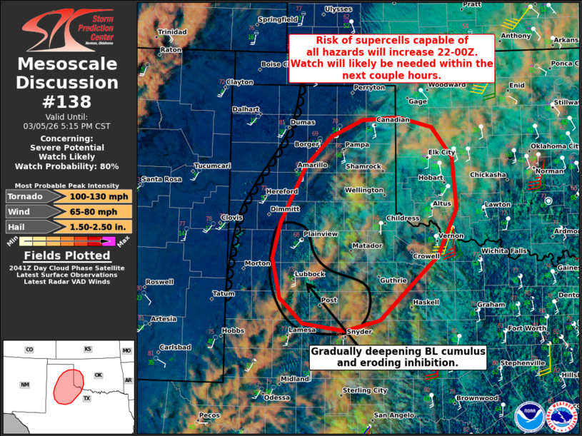
   Mesoscale Discussion 0138
   NWS Storm Prediction Center Norman OK
   0247 PM CST Thu Mar 05 2026

   Areas affected...Parts of the TX Panhandle and South Plains into
   southwestern OK

   Concerning...Severe potential...Watch likely

   Valid 052047Z - 052315Z

   Probability of Watch Issuance...80 percent

   SUMMARY...The risk of supercells capable of all hazards will
   increase between 22-00Z, and continue into tonight. A watch will
   likely be needed for parts of the area within the next couple hours.

   DISCUSSION...The latest visible satellite imagery depicts gradually
   deepening boundary-layer cumulus developing over parts of the TX
   South Plains -- where steepening low-level lapse rates are impinging
   on sheltered/increasing boundary-layer moisture (upper 50s
   dewpoints). As diurnal heating and low-level warm advection continue
   in this corridor, antecedent inhibition at the base of the EML
   should erode and support convective initiation in the 22-00Z time
   frame. While uncertain, additional storm development is also
   possible within zones of subtle differential heating farther
   northeast in the TX Panhandle, where the low-level warm advection is
   a bit stronger.

   Steep midlevel lapse rates and the aforementioned moisture will
   contribute to moderate surface-based buoyancy, which combined with
   around 40 kt of effective shear, will favor discrete/semi-discrete
   supercells -- given generally weak forcing for ascent. Initial
   storms will pose a risk of large hail and severe gusts, though a
   gradually strengthening low-level jet and expanding low-level
   hodographs will lead to an increasing tornado risk into this
   evening. The weak forcing for ascent and lingering inhibition does
   cast uncertainty on overall timing/evolution of the severe risk,
   though current thinking is that a watch will likely be needed within
   the next couple hours.

   ..Weinman/Guyer.. 03/05/2026

   ...Please see www.spc.noaa.gov for graphic product...

   ATTN...WFO...OUN...SJT...LUB...AMA...MAF...

   LAT...LON   33880224 34420209 35270164 35720117 35980060 36019995
               35869933 35419896 34629889 33929924 32950029 32790092
               32910168 33280210 33880224

   MOST PROBABLE PEAK TORNADO INTENSITY...100-130 MPH
   MOST PROBABLE PEAK WIND GUST...65-80 MPH
   MOST PROBABLE PEAK HAIL SIZE...1.50-2.50 IN
|
|
|
Top/All Mesoscale Discussions/Forecast Products/Home |
|
Source link