| Mesoscale Discussion 2269 | |
| < Previous MD | |
|
|
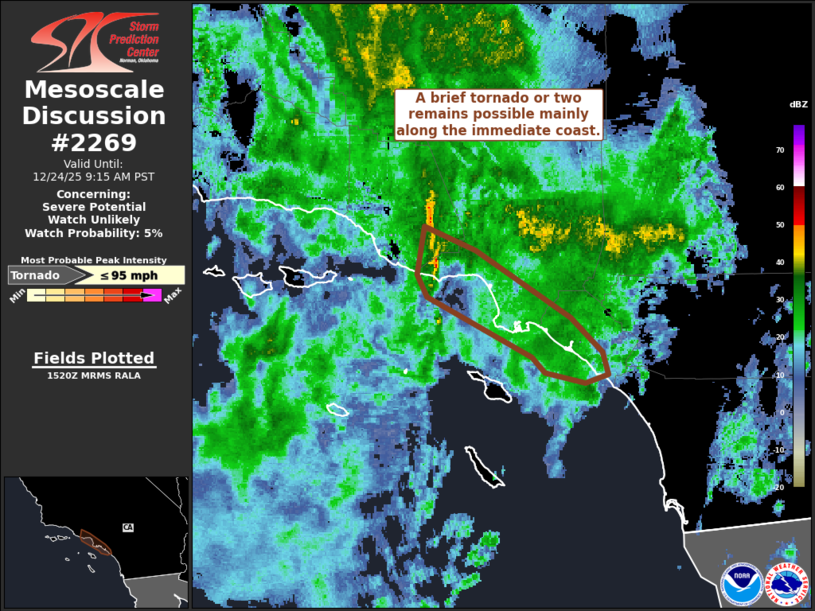
   Mesoscale Discussion 2269
   NWS Storm Prediction Center Norman OK
   0922 AM CST Wed Dec 24 2025

   Areas affected...Portions of the southern California Coast

   Concerning...Severe potential...Watch unlikely

   Valid 241522Z - 241715Z

   Probability of Watch Issuance...5 percent

   SUMMARY...A brief tornado is possible along the immediate coast as a
   shallow convective band moves east this morning.

   DISCUSSION...A shallow band of convection, not currently deep enough
   to support lightning production, continues to move eastward into the
   LA Basin region ahead of a strong shortwave trough. The strongest
   parts of this band remain near the coastline where dewpoints appear
   to be in the low 60s F. Prior to the passage of this activity, KVTX
   VAD data did show notable low-level shear/SRH. Recent velocity
   imagery has also depicted weak, transient areas of low-level
   rotation. A brief tornado will remain possible as this activity
   continues east. Strong and gusty winds may also accompany the band.
   The primary threat area will likely remain along the immediate coast
   given decreasing surface moisture and buoyancy inland.

   ..Wendt/Gleason.. 12/24/2025

   ...Please see www.spc.noaa.gov for graphic product...

   ATTN...WFO...SGX...LOX...

   LAT...LON   33911889 34031895 34311890 34181855 33971821 33781789
               33581766 33461763 33411778 33461806 33551816 33911889

   MOST PROBABLE PEAK TORNADO INTENSITY...UP TO 95 MPH
|
|
|
Top/All Mesoscale Discussions/Forecast Products/Home |
|
Source link