| Mesoscale Discussion 2266 | |
| < Previous MD | |

|
|
Mesoscale Discussion 2266
NWS Storm Prediction Center Norman OK
0405 AM CST Wed Dec 24 2025
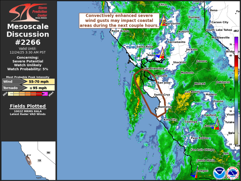
Areas affected...Central/Northern California Coast
Concerning...Severe potential...Watch unlikely
Valid 241005Z - 241130Z
Probability of Watch Issuance...5 percent
SUMMARY...Convectively enhanced severe wind gusts may impact coastal
areas from Monterey Bay to the Bay Area during the next couple
hours.
DISCUSSION...Latest radar data from KMUX shows a loosely organized
line segment with a northern book-end mesovortex moving
east-northeastward at around 50 kt toward the Monterey Bay area.
Despite limited buoyancy (especially over land areas), very strong
wind fields (60+ kt in the lowest 1 km AGL per KMUX VWP) and
relatively moist conditions/neutral static stability in the boundary
layer may support convectively enhanced severe wind gusts and
perhaps a brief tornado risk over the next couple hours as this
activity moves ashore over the immediate coastal areas.
..Weinman/Smith.. 12/24/2025
...Please see www.spc.noaa.gov for graphic product...
ATTN...WFO...MTR...
LAT...LON 37422270 37632277 37802249 37762222 37592200 36852160
36492157 36352186 36492212 37422270
MOST PROBABLE PEAK TORNADO INTENSITY...UP TO 95 MPH
MOST PROBABLE PEAK WIND GUST...55-70 MPH
|
|
|
Top/All Mesoscale Discussions/Forecast Products/Home |
|
Source link