| Mesoscale Discussion 2248 | |
| < Previous MD | |
|
|
Mesoscale Discussion 2248
NWS Storm Prediction Center Norman OK
1234 PM CST Tue Dec 02 2025
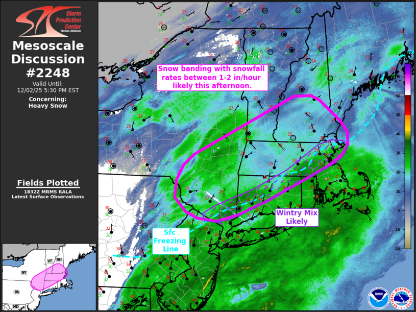
Areas affected...Southern New York into New England
Concerning...Heavy snow
Valid 021834Z - 022230Z
SUMMARY...Heavy snowfall rates between 1-2 inches per hour remain
likely across southern New York into portions of New England this
afternoon.
DISCUSSION...Latest radar mosaics show the development of a snow
band across portions of south/southeastern New York in response to
strengthening frontogenesis between the 925-850 mb levels across the
Mid-Atlantic/New England coast. Surface observations and web cams
under this band are reporting visibility reductions between 1/4 to
1/2 mile, which given weak winds across the region, are likely being
driven primarily by moderate to heavy snowfall rates. Broad-scale
ascent ahead of an approaching upper wave and more focused mesoscale
ascent within the warm advection branch of an intensifying low-level
cyclone (augmented by frontogenetical responses) will remain
favorably phased through the remainder of the afternoon over the
greater New England region. This will continue to favor widespread
light/moderate precipitation and the maintenance and/or development
of heavier precipitation bands. Consequently, snowfall rates between
1-2 inches/hour will remain likely for areas north of the surface
freezing line. Nearly isothermal temperature profiles from the
surface to around 850 mb suggests that areas near the surface
freezing line may continue to see rapid fluctuations in
precipitation type between snow, sleet, and potentially freezing
rain.
..Moore.. 12/02/2025
...Please see www.spc.noaa.gov for graphic product...
ATTN...WFO...GYX...BOX...BTV...OKX...ALY...PHI...BGM...
LAT...LON 42227105 41537270 41247350 41107407 41167459 41297490
41587521 41947516 42257497 42457469 43647197 43657149
43567127 43127069 42887051 42647051 42457066 42227105
|
|
|
Top/All Mesoscale Discussions/Forecast Products/Home |
|
Source link