| Mesoscale Discussion 2225 | |
| < Previous MD | |
|
|
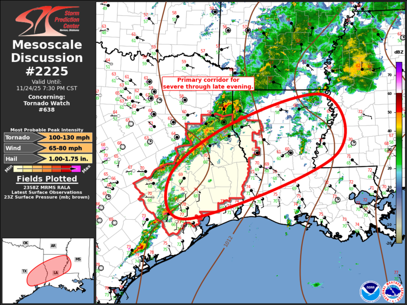
Mesoscale Discussion 2225 NWS Storm Prediction Center Norman OK 0601 PM CST Mon Nov 24 2025 Areas affected...Southeast TX into the lower Mississippi Valley Concerning...Tornado Watch 638... Valid 250001Z - 250130Z The severe weather threat for Tornado Watch 638 continues. SUMMARY...Scattered thunderstorms will spread across southeast Texas into the lower Mississippi Valley this evening. Some risk for tornadoes exists with the most robust convection. New Tornado Watch will likely be warranted by 25/01z. DISCUSSION...Latest water-vapor imagery depicts a well-defined short-wave trough in the southern stream over the Hill Country of south central TX. This feature will approach the lower Sabine River Valley later this evening which may encourage the warm front to eventually lift a bit north across northern LA/central MS later tonight. While more buoyant air mass is noted across southeast TX into southern LA, stronger low-level warm advection will be focused along the AR/LA border into northern MS, coincident with stronger 850mb flow (LLJ). Over the last hour or so, convection has gradually increased in intensity from near VCT-southern Madison County TX. The aforementioned short wave is likely aiding this activity. Current thinking is large-scale support will spread downstream this evening and likely prove instrumental in new development across the lower MS Valley. Shear profiles remain supportive of supercells, and adequate SBCAPE exists across this region for robust updrafts and possible tornadoes. New Tornado Watch will likely be issued by 25/01z. ..Darrow.. 11/25/2025 ...Please see www.spc.noaa.gov for graphic product... ATTN...WFO...JAN...LIX...LCH...SHV...HGX... LAT...LON 30789588 32149407 32869124 31279099 29689531 30789588 MOST PROBABLE PEAK TORNADO INTENSITY...100-130 MPH MOST PROBABLE PEAK WIND GUST...65-80 MPH MOST PROBABLE PEAK HAIL SIZE...1.00-1.75 IN |
|
|
Top/All Mesoscale Discussions/Forecast Products/Home |
|
Source link