| Mesoscale Discussion 2205 | |
| < Previous MD | |
|
|
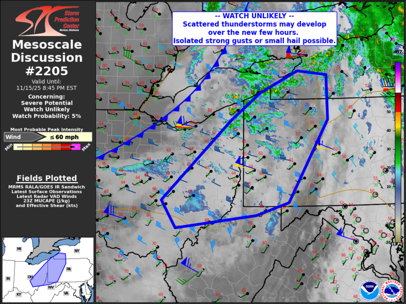
   Mesoscale Discussion 2205
   NWS Storm Prediction Center Norman OK
   0514 PM CST Sat Nov 15 2025

   Areas affected...eastern Ohio...western Pennsylvania...far western
   New York and northern West Virginia

   Concerning...Severe potential...Watch unlikely

   Valid 152314Z - 160145Z

   Probability of Watch Issuance...5 percent

   SUMMARY...Scattered thunderstorms may develop over the next few
   hours. This activity should mostly be non-severe, but isolated
   strong gusts or small hail may occur through the evening.

   DISCUSSION...A cold front continues to develop into southwest
   Ontario and extending southwestward across western OH. Daytime
   heating as well as southwest winds ahead of this front has resulted
   in a plume of 50s F dewpoints, with minimal instability due to cool
   surface temperatures.

   Although diurnal heating is lost, eventual cooling aloft across
   northern parts of the area may maintain at least marginal elevated
   instability due to steepening midlevel lapse rates. Sufficient
   large-scale lift of the relatively moist air mass ahead of the front
   may then yield scattered thunderstorms from eastern OH into PA and
   vicinity. Due to the weak instability, severe weather is not
   anticipated. However, strong winds just off the surface of 40+ kt
   may yield locally enhanced wind gusts with any downdrafts.

   ..Jewell/Hart.. 11/15/2025

   ...Please see www.spc.noaa.gov for graphic product...

   ATTN...WFO...BUF...CTP...PBZ...RLX...CLE...ILN...

   LAT...LON   39258237 39848277 41548087 42138004 42607899 42507817
               41557815 39807926 39528015 39258237

   MOST PROBABLE PEAK WIND GUST...UP TO 60 MPH
|
|
|
Top/All Mesoscale Discussions/Forecast Products/Home |
|
Source link