|
|
| Mesoscale Discussion 2196 | |
|
|
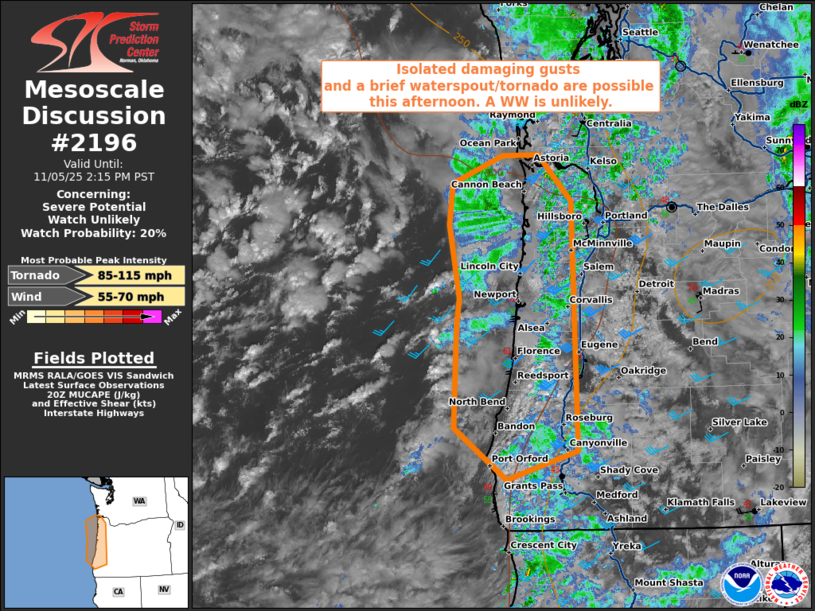
   Mesoscale Discussion 2196
   NWS Storm Prediction Center Norman OK
   0209 PM CST Wed Nov 05 2025

   Areas affected...Coastal Oregon

   Concerning...Severe potential...Watch unlikely

   Valid 052009Z - 052215Z

   Probability of Watch Issuance...20 percent

   SUMMARY...Isolated to widely-scattered low-topped storms are
   expected to move onshore over the next few hours. Very strong shear
   profiles will support some storm organization, with damaging gusts
   and a brief waterspout/tornado possible. Conditions will be
   monitored, but a WW is currently not anticipated.

   DISCUSSION...As of 2005 UTC, afternoon water-vapor imagery showed a
   strong shortwave trough moving onshore over the Pacific Northwest
   within a broader Pacific upper low. Regional VWPs continue to show
   strong mid-level flow with ample low-level shear as a jet streak
   south of the main trough moves onshore. Beneath the upper low, cold
   mid-level temperatures (-22 to -24 C) and filtered diurnal heating
   within a moist maritime air mass are steepening low-level lapse
   rates and supporting weak buoyancy (MUCAPE around 500 J/kg). Strong
   ascent and continued destabilization should allow for several rounds
   of thunderstorms to move onshore over western OR this afternoon and
   evening.

   Already, low-topped cells have gradually intensified, with a notable
   increase in lightning near the mouth of the Columbia River and
   father offshore. As these storms move inland, downward momentum
   transfer of the strong mid-level flow (50+ kt at 4km AGL) should
   allow for isolated damaging gusts as downdrafts become established.
   Enlarged veering hodographs (ESRH 200-250 m2/s2) may also support
   the potential for a waterspout/brief tornado with any transient
   rotating storms. However, the weak buoyancy should limit broader
   organized severe potential.

   ..Lyons/Smith.. 11/05/2025

   ...Please see www.spc.noaa.gov for graphic product...

   ATTN...WFO...MFR...PQR...

   LAT...LON   42912311 42572423 43172506 44332503 44652499 45502516
               45972511 46282429 46302372 45762318 42912311

   MOST PROBABLE PEAK TORNADO INTENSITY...85-115 MPH
   MOST PROBABLE PEAK WIND GUST...55-70 MPH
|
|
|
Top/All Mesoscale Discussions/Forecast Products/Home |
|
Source link