|
|
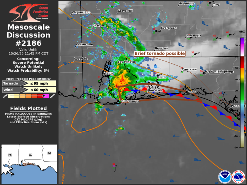
| Mesoscale Discussion 2186 | |

|
|
   Mesoscale Discussion 2186
   NWS Storm Prediction Center Norman OK
   1011 PM CDT Sun Oct 26 2025

   Areas affected...coastal AL and western FL Panhandle

   Concerning...Severe potential...Watch unlikely

   Valid 270311Z - 270445Z

   Probability of Watch Issuance...5 percent

   SUMMARY...A brief tornado is possible with potential intensification
   of a transient supercell tracking along a quasi-stationary front.
   Limited spatial extent and marginal nature of the tornado threat
   will preclude a watch issuance.

   DISCUSSION...Multiple transient circulations have occurred over the
   past 2-3 hours with a slow-moving, but persistent updraft that has
   evolved from near Dauphin Island across a part of Mobile Bay into
   Baldwin County, AL. Each circulation attempt has eventually
   broadened/diminished amid weakness in the 1-3 km portion of the
   hodograph, per the MOB VWP, and poor tropospheric lapse rates
   sampled in available 00Z RAOBs. Nevertheless, this updraft may track
   eastward along the quasi-stationary front that extends overland
   across Pensacola to Santa Rosa Island. Potential for brief
   tornadogenesis may persist through about 06Z along this corridor.

   ..Grams/Hart.. 10/27/2025

   ...Please see www.spc.noaa.gov for graphic product...

   ATTN...WFO...TAE...MOB...

   LAT...LON   30518774 30558731 30568708 30418634 30278620 30308645
               30328695 30268768 30518774

   MOST PROBABLE PEAK TORNADO INTENSITY...UP TO 95 MPH
   MOST PROBABLE PEAK WIND GUST...UP TO 60 MPH
|
|
|
Top/All Mesoscale Discussions/Forecast Products/Home |
|
Source link