Headlines
- Beryl slowly gathering strength en route to Matagorda Bay area or just east.
- Gusty wind, power outages likely in the Houston Metro.
- Heavy rain and flooding will follow Beryl through Houston into northeast Texas and even into the Midwest and Northeast.
Tropical Storm Beryl (70 mph, NNW 12 mph)
Beryl is on the cusp of regaining hurricane status this evening as it lumbers its way north northwest through the western Gulf of Mexico. At this point, it’s mostly a waiting game as the outer bands of the core are almost ashore near Matagorda.
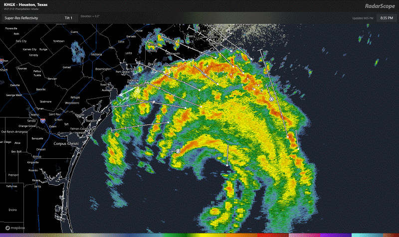
Beryl has thrown many curve balls at us during its life cycle, and the one curve tonight is whether or not its inner core has completely shed the dry air it took in yesterday off Mexico. Satellite imagery suggests it has not shed this dry air, and that may be what has kept Beryl from looking like it’s ready to take off today. The cinnamon bun look to Beryl on radar is another tell-tale sign of this. It’s organizing and strengthening; it’s just slow and steady. It is somewhat fortunate that it took in that dry air yesterday because otherwise, we would almost certainly have a rapidly intensifying hurricane approaching Texas tonight.
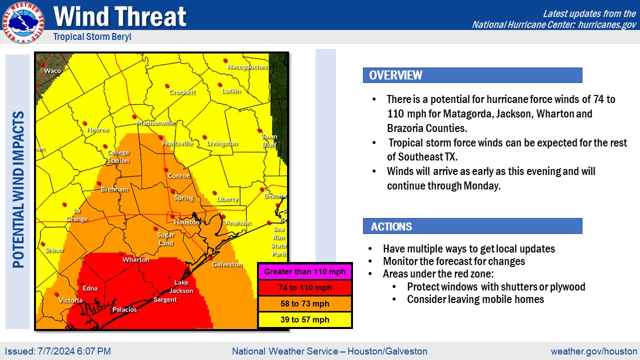
With the storm likely to make landfall between midnight and 3 AM, it has roughly 6 to 8 hours to do whatever it is going to do. This certainly caps the upside of intensity a bit, and it feels a little difficult to think a category 2 will happen here. Category 1? Certainly a possibility, even a likelihood. And really, it becomes mostly a technicality at that point. We still expect hurricane-force winds in the Matagorda Bay region, perhaps into Brazoria County and 10 to 20 miles inland from there. Tropical storm force winds will likely overspread much of the Houston metro. I would say widespread power outages remain a good bet, though the hope will be that the damage is cosmetic enough that restoration will take less than 5 to 7 days for most people. That’s somewhat speculative but that’s the hope.
Meanwhile, the rainfall story will be status quo, Heavy rain is expected along and to the right of Beryl’s track into Texas. This will lead to a pretty healthy flash flooding event in the Houston area and beyond. The limit is on how quickly Beryl will move, which should help cap rain totals somewhat. Still, travel will be difficult in Houston and other parts of Texas overnight and Monday morning.
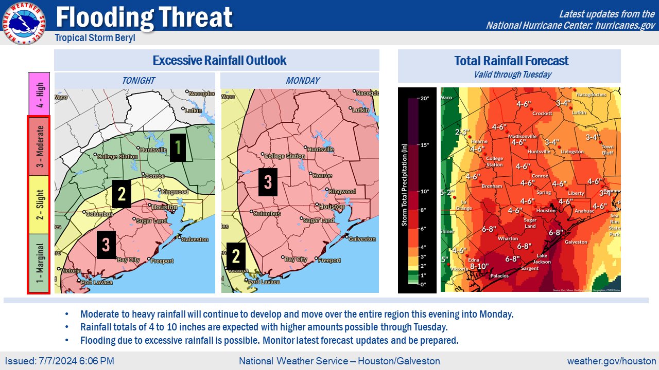
The flash flooding threat will lift quickly into northeast Texas and parts of the Piney Woods tomorrow afternoon. Beryl will assist in bringing heavy rain all the way north into parts of the Midwest, including near Chicago and into Michigan and Indiana. The remnants will be absorbed into a front and system that moves into New England by Wednesday or so as well, so a flooding threat from Beryl may extend far from where it comes ashore tonight.
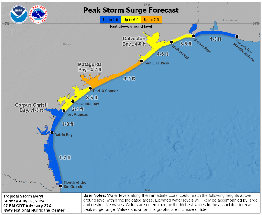
Storm surge will also be an issue near and east of where Beryl comes ashore.

These levels will probably be a bit higher than what we saw in Alberto in many places near and east of where Beryl comes ashore, especially between Galveston and East Matagorda Bay. There will be some considerable inundation in some spots with the morning high tide cycle Monday.
And continued risk of isolated tornadoes will continue tonight and tomorrow as Beryl lifts north.
Anyway, this is going to be our last regular post on Beryl. We will update The Eyewall again tomorrow afternoon with a recap on Beryl and a quick word or two about what’s next in the tropics.
Space City Weather will be with you through the night for Houston. Look for another post soon from Eric, and I’ll have a post up there overnight after landfall. I’ll also be active on Twitter/X and Threads through the night when I’m not trying to catch a nap. Follow us on Instagram or TikTok as well for a video update or two.
Source link