After some 60 deaths in major severe-weather outbreaks on March 24 and March 31, one more round of severe weather with strong tornadoes is possible from Tuesday into Wednesday, April 4-5. These outbreaks have been triggered by powerful upper-level storms rolling along an intense jet stream, slamming into California and then progressing into the central states.
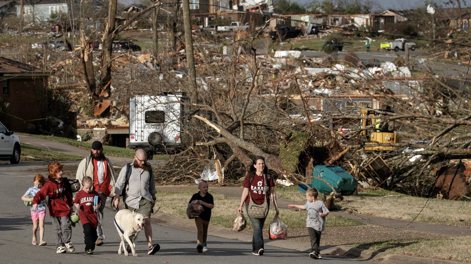
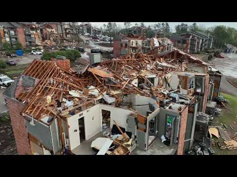
At least 32 people died in a far-flung outbreak that unfolded from Friday into Saturday. While no single tornado in this episode produced a death toll on par with the 13 lives lost in Rolling Fork, Mississippi, on March 24, there were killer tornadoes on Friday and Saturday in states extending from Arkansas to Delaware.
A large EF3 tornado early Friday afternoon damaged or destroyed hundreds of homes and businesses along a broad, 22-mile-long path that ground across western Little Rock and the city of North Little Rock, Arkansas. At least three people were killed and more than 50 were injured. It was Pulaski County’s strongest tornado since an F4 struck on Jan. 21, 1999.
Another supercell spawned an intense EF3 tornado about two hours later that devastated the town of Wynne in east-central Arkansas, taking at least four lives there.

A dramatic, widely photographed EF4 tornado churned from near Martinsburg to near Wellman, Iowa, over roughly an hour’s time on Friday afternoon. Damage was scattered, as large towns and cities were spared. At least 10 other tornadoes occurred in southeast Iowa and northwest Illinois, and surveys were ongoing Monday ahead of the next severe-weather outbreak expected on Tuesday.
At least 16 tornadoes occurred in the NWS/Chicago region. The area’s only killer tornado on Friday was an EF1 twister that struck Belvidere, Illinois, around 7:45 p.m. CDT with winds estimated at 100 mph. A tornado warning was issued about 20 minutes before the tornado reached downtown Belvidere, where a concert was in progress at the Apollo Theater. Just minutes after the music was paused because of the tornado warning, part of the theater’s ceiling collapsed onto concertgoers, killing one person and injuring 40 others.
An EF3 tornado took a 13-mile bi-state path around 10 p.m. EDT Friday, moving from southeast Illinois into southwest Indiana. Three people were killed and eight injured as the tornado moved over and near Sullivan, Indiana, damaging or destroying dozens of homes.
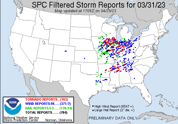
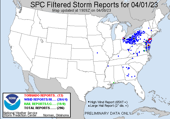
The Friday-Saturday outbreak by the numbers
As of midday Monday, the Storm Prediction Center database of preliminary tornado reports, both before and after an initial filter applied by the center, included:
- 12Z (8 a.m. EDT) Fri. 3/31 to Sat. 4/1: 124 tornado reports (109 filtered reports) in Alabama, Arkansas, Georgia, Illinois, Indiana, Iowa, Mississippi, Ohio, Tennessee, and Wisconsin
- 12Z Sat. 4/1 to Sun. 4/2: 8 tornado reports (8 filtered reports) in Michigan, Delaware, Maryland, New Jersey
These preliminary tallies were still a work in progress on Monday, as surveyors continued to comb through wreckage. Typically in an outbreak this huge, some additional tornadoes end up being documented while a number of reports are found to be duplications. On average, the final tornado count from an outbreak is at least two-thirds of the preliminary count.
As of midday Monday, at least 85 tornadoes had been confirmed, including the EF4 tornado in Iowa and nine EF3 tornadoes.
During the period of official NOAA tornado records (1950-present), only a few outbreaks have produced 100 or more tornadoes. Tornado reports roughly doubled from the 1950s to the 1990s, as storm-survey practices improved and storm spotting and chasing greatly expanded. The number of strong tornadoes (EF2-EF3) and violent tornadoes (EF4-EF5) has not shown any significant trend since the 1970s.
Climate change is likely involved with tornadoes becoming concentrated into more intense outbreaks, as well as the prevalence of tornadoes decreasing across the Southern Plains and increasing farther to the east across the highly vulnerable Mississippi Valley and Southeast. Model simulations published in January suggest that the overall number of U.S. supercells, which produce the most dangerous, longest-lived tornadoes, may increase by around 5 to 15% between 1990-2005 and 2085-2100, depending on emission trends.
Read: Climate change and tornadoes: Any connection?
A comprehensive Wikipedia site based on NOAA reports shows a total of seven multiday sequences of at least 100 tornadoes over the 4-decade period from 1950 through 1989, jumping to six to nine such sequences in each decade since 1990. The most recent was on Dec. 15, 2021, when a dramatically out-of-season outbreak produced 120 tornadoes in just a few hours.

Déjà vu all over again: Another bimodal tornado threat on Tuesday, with serious nighttime tornadoes possible
Late Tuesday afternoon and Tuesday night may see tornadic storms unfolding over some of the same areas hammered on Friday, especially from Arkansas and Missouri into Iowa and Illinois. The Storm Prediction Center’s Day 2 risk area issued at midday Monday for Tuesday is another bimodal outlook, with moderate-risk zones at the southern and northern ends that are unusually similar to what those issued in advance for last Friday, albeit positioned a bit farther west.
There are other key differences between Friday and Tuesday — the most important being time of day. A capping layer of storm-suppressing warm air, roughly a mile above ground level, is projected to be stronger on Tuesday than it was on Friday. This will likely keep supercells from erupting until late afternoon or evening, hours later than occurred Friday. In addition, the warm-sector air on Tuesday will be warmer and more humid, which will contribute to even greater instability that could help tornadic storms continue well after nightfall. Moreover, instead of plowing eastward quickly as occurred on Friday, the latest upper-level storm system will be lifting more toward the northeast. This means a slower-moving cold front and the potential for multiple rounds of storms, perhaps extending after midnight in some areas.
The Storm Prediction Center is stressing the unusually high potential of nighttime tornadic storms that could develop as late as 1-2 a.m. CDT from northeast Texas into southwest Missouri.
As the upper-level storm pushes into the Great Lakes on Wednesday, another round of severe weather could develop from eastern Michigan into Indiana, Ohio, and western Pennsylvania and New York. While the collective strength of Wednesday’s storms should be less than on Tuesday, tornadoes could occur with a potential squall line as well as any supercells that might form ahead of the line.
After Wednesday, the jet stream will weaken and lift toward Canada, ushering in what could be a week or more of relatively tranquil spring weather and greatly reduced severe-weather potential.
Jeff Masters contributed to this post.
Website visitors can comment on “Eye on the Storm” posts. Comments are generally open for 30 days from date posted. Sign up to receive email announcements of new postings here. Twitter: @DrJeffMasters and @bhensonweather
Source link