Nicole made the transition from a subtropical storm to a tropical storm Tuesday morning, and this change in structure has allowed it to begin an intensification phase. Nicole has made a turn to the west toward the northwestern Bahamas and Florida and is expected to make landfall early Thursday morning in Florida as a category 1 hurricane. Because of Nicole’s large size, impacts from the storm will extend far to the north, and a damaging storm surge is likely along most of the Southeast U.S. coast from central Florida to North Carolina.
Nicole is a large storm – and that means widespread coastal flooding
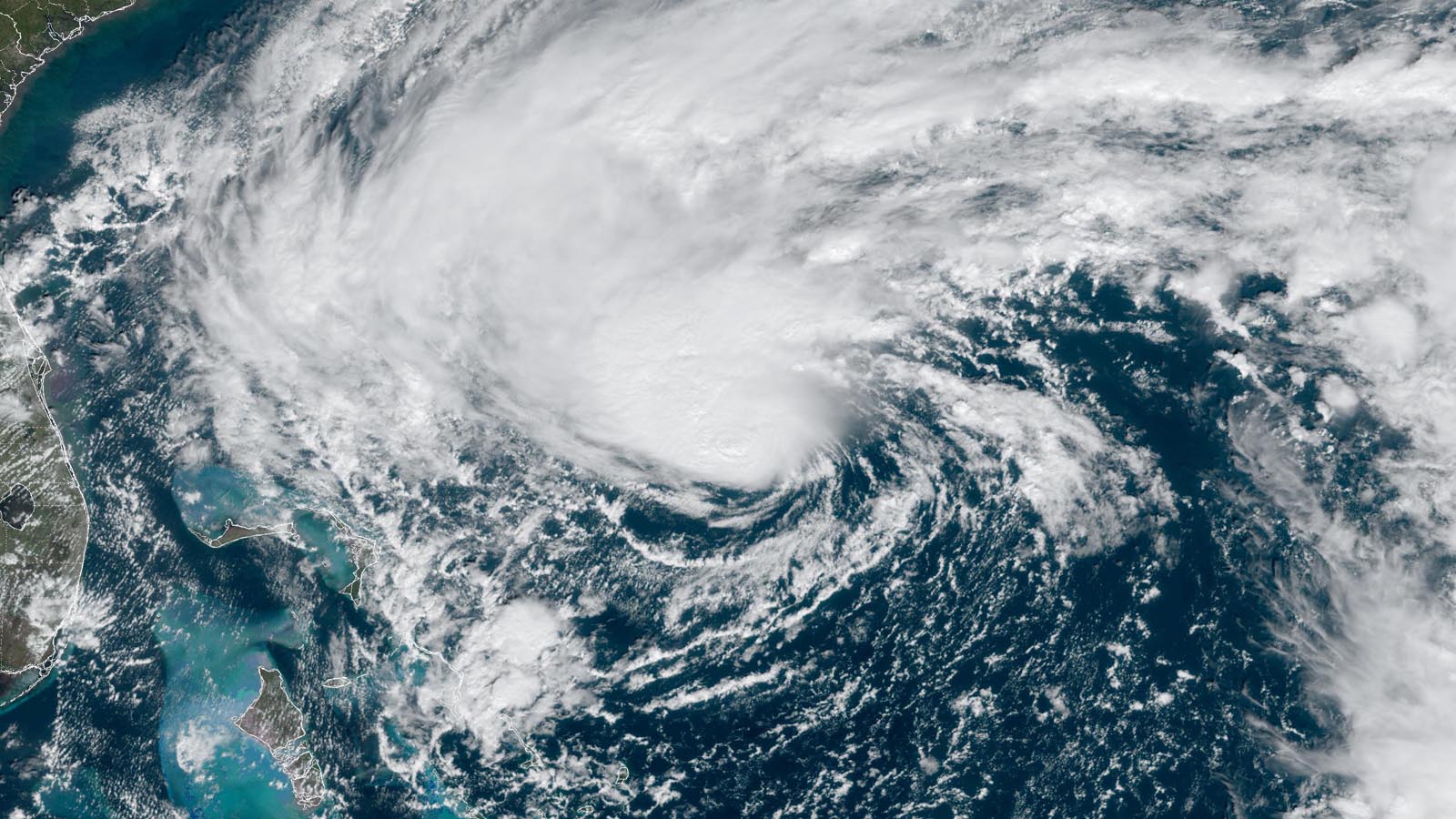
At 1 p.m. EST Tuesday, Nicole was centered about 420 miles east of West Palm Beach, Florida, headed west at 9 mph, with maximum sustained winds of 60 mph and a central pressure of 992 mb. Satellite images showed that Nicole still had somewhat of a subtropical appearance, with heavy thunderstorm activity in wide bands arcing to the west, north, and east of the center. However, Nicole had developed a concentrated area of intensifying heavy thunderstorms near its circulation center, and this change in structure prompted the National Hurricane Center (NHC) to define Nicole as a tropical storm rather than a subtropical storm on Tuesday morning. Thunderstorm coverage was thin on the south side, though, where dry air was present.
Nicole was a large storm, with tropical-storm-force winds that covered a region of ocean larger than the state of Florida. The breadth of Nicole’s tropical-storm-force winds is remarkable; less than 2% of all 6-hourly named storm “fixes” since 2004 showed such a large wind field, according to Michael Lowry.
Nicole had modestly favorable conditions for development, with very warm ocean waters for this time of the year of 27-28 degrees Celsius (81-82°F) – about 1 degree Celsius (1.8°F) above average. However, there was plenty of dry air on the south side of the storm, associated with a decaying upper-level low-pressure system. Upper-level winds out of the southwest were creating moderate wind shear of 10 -20 knots, and these winds were driving dry air into the core of Nicole, slowing development.


Track forecast for Nicole
Nicole will continue to the west or west-southwest through Wednesday evening, when this track will bring it very near the northwestern Bahamas, where hurricane warnings are in effect. On Wednesday night or early Thursday morning, steering currents will shift and drive Nicole more to the west-northwest into the east coast of Florida. The timing of this shift is still fuzzy in the models, and the center of Nicole could cross the coast anywhere between West Palm Beach and Daytona Beach.
As Nicole crosses the Florida Peninsula, a trough of low pressure passing to the north will turn the storm to the north and then northeast, and it’s possible Nicole will briefly reemerge over the northeast Gulf as a weaker system. Tropical storm watches are up for much of the Gulf Coast of Florida; 1-3 feet of storm surge is expected in Tampa Bay, with 2-4 feet from Tampa Bay to the Suwannee River.


Intensity forecast for Nicole: slow intensification
As Nicole heads toward Florida on Tuesday and Wednesday, wind shear is predicted to increase a notch, to 15-25 knots, as strong upper-level winds out of the southwest from the subtropical jet stream affect the storm. Dry air and wind shear will combine to slow development of an inner core, and none of the top intensity models are predicting rapid intensification of Nicole. The 12Z Tuesday runs of the SHIPS and DTOPS models gave less than an 8% chance of rapid intensification (an increase of at least 35 mph in wind speed in 24 hours).
The Tuesday morning suite of intensity model forecasts predicted that Nicole would make landfall in Florida with top sustained winds between 55 and 75 mph (i.e., as a strong tropical storm or category 1 hurricane). Given the large size of Nicole, and the unfavorable levels of wind shear and dry air, intensification into a category 2 hurricane is not expected.
Nicole is expected to bring a swath of 3-5 inches of rain along its path across Florida and northward into the Southeast U.S.; the dry air to Nicole’s southwest will likely limit rainfall over extreme South Florida. The St. Johns River, which winds through northeastern Florida to the north of Orlando, was still at moderate flood stage this week because of Hurricane Ian’s rains at the end of September. Nicole’s rains are predicted to cause the river to rise again (Figure 4).
Nicole is expected to bring a wide swath of 2-4 inches of rain to the mid-Atlantic and Northeast. These rains will likely cause some isolated flooding, but will also help alleviate drought conditions present over portions of the region.


The king tides are here
The arrival of the full moon on Tuesday is bringing some of the highest tides of the year this week – the king tides. Minor coastal flooding was observed at multiple locations along the coast of Florida during the morning high tide on Tuesday from the combined influences of the king tides and onshore flow driven by an unusually strong high-pressure system to the north of Nicole. Water levels along the Southeast U.S. coast on Wednesday morning will be particularly elevated from three factors: the king tides, strong high pressure to the north of Nicole, and the approach of Nicole. A probabilistic storm surge product from NOAA is estimating that water levels on three consecutive high tide cycles, Wednesday through Thursday, could exceed the modern record set during Hurricane Matthew in 2016 in Jacksonville, Florida: 3.22 feet above high tide (MHHW). Matthew’s storm surge caused tens of millions of dollars in damage to northeastern Florida, washing out portions of State Highway A1A.
Although the NHC storm surge watch for Nicole extends only to Georgia, damaging coastal flooding will extend well north of there. Major coastal flooding is predicted in Charleston, South Carolina, during the Thursday morning high tide, and a coastal flood watch for a storm surge of 1-3 feet is posted for much of coastal North Carolina.

Nicole will bring some of the lowest pressure readings ever recorded in November along the Southeast coast, a location where the month is too late in the season for most tropical cyclones and too early for most winter-type nor’easters.
Nicole predicted to generate 30-foot waves
Coastal damage will be especially high just to the north of where Nicole’s center crosses the coast; waves offshore there are predicted to reach 30 feet (see Tweet above). High waves on top of a large storm surge at high tide during the king tides are a recipe for significant coastal damage and beach erosion.


November landfalling storms are rare in the U.S.
According to the NOAA hurricane database, 10 tropical storms and three hurricanes have made landfall in the continental U.S. in November or December since records began in 1851 – an average of one late-season landfall every 13 years. Only two of these storms made a direct strike on Florida’s east coast: the Yankee Hurricane of 1935, which hit just north of Miami Beach on Nov. 4 as a category 2 hurricane with 100 mph winds, and Tropical Storm Seven of 1946, which made landfall in Boynton Beach with 45 mph winds on Nov. 1.
Website visitors can comment on “Eye on the Storm” posts (see comments policy below). Sign up to receive notices of new postings here.
Source link