| Mesoscale Discussion 99 | |
| < Previous MD | |

|
|
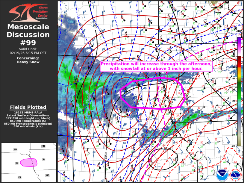
   Mesoscale Discussion 0099
   NWS Storm Prediction Center Norman OK
   1218 PM CST Thu Feb 19 2026

   Areas affected...Eastern Nebraska and western Iowa

   Concerning...Heavy snow

   Valid 191818Z - 200015Z

   SUMMARY...Heavy snow is expected to develop eastward into eastern
   Nebraska through the afternoon and reach western Iowa this evening.
   Snowfall rates could exceed 1 inch per hour for a few hours.

   DISCUSSION...A midlevel shortwave trough and associated low-midlevel
   ascent will spread eastward from central into eastern NE through the
   remainder of the afternoon.  An initially dry column with a small
   warm nose will cool/saturate as precipitation forms and increases in
   intensity from west-to-east, with snow expected to be the primary
   precipitation type as a result of wet bulb temperatures well below 0
   C.  Focused ascent through the dendritic growth layer (driven
   primarily by warm advection/frontogenesis 850-600 mb) will support
   snowfall at or above 1 inch per hour later this afternoon/evening.

   ..Thompson.. 02/19/2026

   ...Please see www.spc.noaa.gov for graphic product...

   ATTN...WFO...DMX...FSD...OAX...GID...LBF...

   LAT...LON   41799835 42109777 42249638 42209567 41979531 41439514
               41159540 41079627 41139780 41489833 41799835
|
|
|
Top/All Mesoscale Discussions/Forecast Products/Home |
|
Source link