| Mesoscale Discussion 96 | |
| < Previous MD | |

|
|
Mesoscale Discussion 0096
NWS Storm Prediction Center Norman OK
0903 AM CST Thu Feb 19 2026
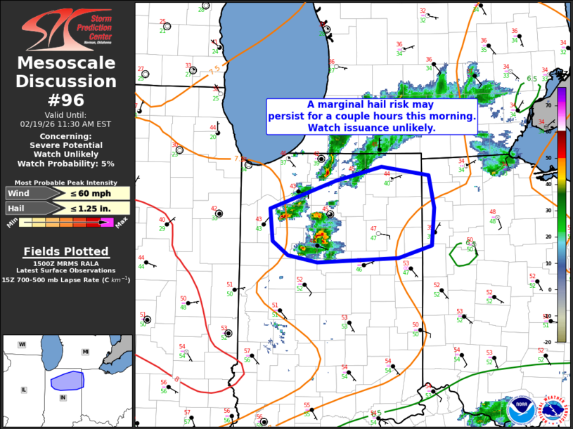
Areas affected...northern Indiana vicinity
Concerning...Severe potential...Watch unlikely
Valid 191503Z - 191630Z
Probability of Watch Issuance...5 percent
SUMMARY...Isolated elevated thunderstorms may produce marginally
severe hail for a couple of hours this morning. The overall risk
should remain limit in magnitude, and a watch is not expected at
this time.
DISCUSSION...Elevated thunderstorms are ongoing this morning within
an area of warm advection to the north of a surface warm front.
Morning regional RAOBs and latest SPC Mesoanalysis indicated cold
temperatures aloft supporting midlevel lapse rates greater than 7
C/km. As a result, MUCAPE has increased to 250-500 J/kg. Sufficient
effective shear for organized storms is present. Furthermore,
elongated hodographs with increasing west/southwesterly flow aloft
are noted. This environment may sporadically support strong storms
producing marginal hail up to around 1 inch in diameter. The
magnitude of this initial convection is expected to remain limit,
precluding watch issuance at this time.
..Leitman/Mosier.. 02/19/2026
...Please see www.spc.noaa.gov for graphic product...
ATTN...WFO...ILN...IWX...IND...LOT...
LAT...LON 41128707 41458609 41618540 41508470 41148462 40718465
40568515 40528636 40598680 40768704 41128707
MOST PROBABLE PEAK WIND GUST...UP TO 60 MPH
MOST PROBABLE PEAK HAIL SIZE...UP TO 1.25 IN
|
|
|
Top/All Mesoscale Discussions/Forecast Products/Home |
|
Source link