| Mesoscale Discussion 90 | |
| < Previous MD | |

|
|
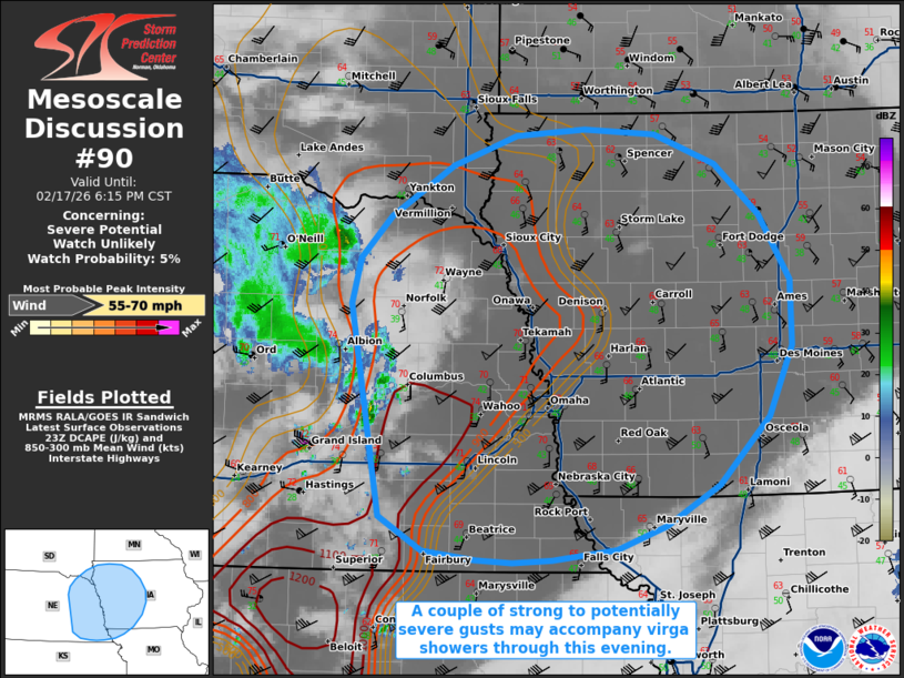
   Mesoscale Discussion 0090
   NWS Storm Prediction Center Norman OK
   0522 PM CST Tue Feb 17 2026

   Areas affected...portions of eastern Nebraska into central Iowa

   Concerning...Severe potential...Watch unlikely

   Valid 172322Z - 180015Z

   Probability of Watch Issuance...5 percent

   SUMMARY...A couple of strong to severe gusts are possible with
   high-based storms this evening and perhaps early tonight.

   DISCUSSION...A mid-level impulse, embedded in broader upper
   troughing, is overspreading the central Plains, resulting in the
   gradual deepening of a surface low over eastern NE. Preceding
   southerly flow just above the surface continues to increase in
   magnitude, and RAP forecast soundings/short-term forecasts depict
   over 50 kts of 925 mb flow poised to overspread far eastern NE into
   central IA as the low-level jet intensifies. A shield of
   high-based/low-topped convection is approaching from the west, and
   will overspread a dry boundary layer over the next few hours. Some
   of the stronger virga showers/possible thunderstorms will promote
   enough evaporative cooling of the stronger flow just above the
   surface, likely resulting in gusty conditions. Given the magnitude
   of the flow just above the surface, it is plausible that damaging to
   perhaps severe gusts could accompany the stronger showers this
   evening.

   The severe threat should remain sparse though, so a WW issuance is
   not anticipated.

   ..Squitieri/Hart.. 02/17/2026

   ...Please see www.spc.noaa.gov for graphic product...

   ATTN...WFO...DMX...EAX...FSD...OAX...GID...

   LAT...LON   40429763 42049793 42389785 42709753 43099690 43329625
               43389556 43339484 43119422 42729377 42229345 41719345
               41179368 40669420 40359473 40169524 40089589 40069629
               40089666 40169720 40429763

   MOST PROBABLE PEAK WIND GUST...55-70 MPH
|
|
|
Top/All Mesoscale Discussions/Forecast Products/Home |
|
Source link