| Mesoscale Discussion 89 | |
| < Previous MD | |

|
|
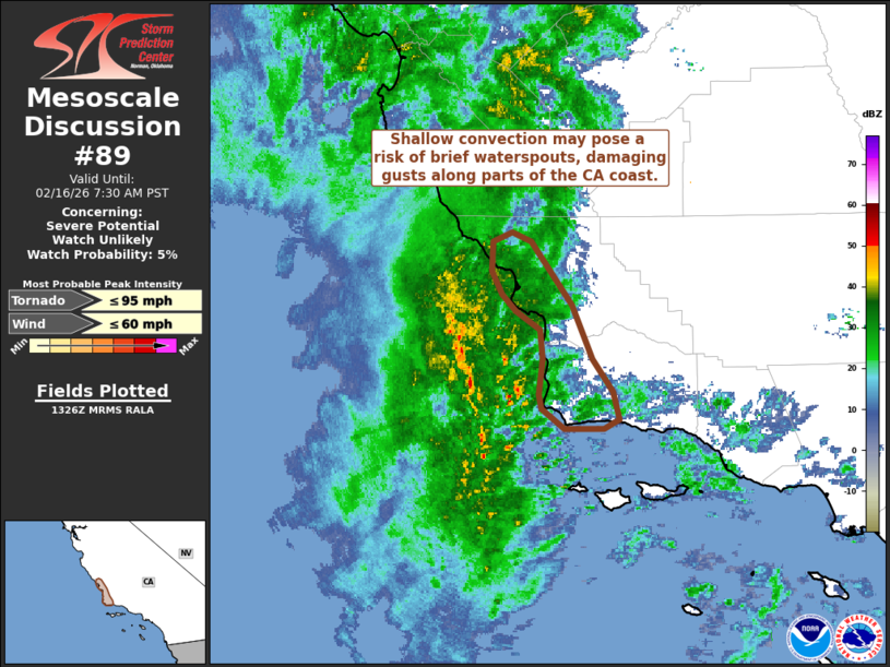
   Mesoscale Discussion 0089
   NWS Storm Prediction Center Norman OK
   0729 AM CST Mon Feb 16 2026

   Areas affected...Portions of the southern California Coast

   Concerning...Severe potential...Watch unlikely

   Valid 161329Z - 161530Z

   Probability of Watch Issuance...5 percent

   SUMMARY...Weak convective showers may pose a threat for waterspouts
   and damaging winds along portions of the southern California coast
   through mid-morning.

   DISCUSSION...Latest radar imagery from KVBX shows shallow convective
   cells moving northward ahead of an eastward migrating convective
   band within a narrow plume of warm air advection. Several of these
   cells show weak rotation per velocity imagery, and while too shallow
   for substantial lightning production, may be capable of brief/weak
   waterspouts given nearly 450 m2/s2 0-1 km SRH sampled by the nearby
   KVBX VWP. These cells will gradually approach the coastline of
   western Santa Barbara and San Luis Obispo counties in the next few
   hours and may pose a risk of waterspouts and damaging winds along
   the shore. This threat is expected to remain fairly spatially
   limited to coastal areas given very limited buoyancy further inland,
   at least for the next few hours before cold temperatures aloft
   spread east. Regardless, the spatial/temporal threat will likely
   remain sufficiently limited to preclude watch issuance.

   ..Moore/Smith.. 02/16/2026

   ...Please see www.spc.noaa.gov for graphic product...

   ATTN...WFO...LOX...

   LAT...LON   34412047 34542066 34642067 34862064 35062066 35182085
               35292097 35442104 35622103 35692089 35622074 35212042
               34862025 34662010 34472005 34422016 34412047

   MOST PROBABLE PEAK TORNADO INTENSITY...UP TO 95 MPH
   MOST PROBABLE PEAK WIND GUST...UP TO 60 MPH
|
|
|
Top/All Mesoscale Discussions/Forecast Products/Home |
|
Source link