| Mesoscale Discussion 81 | |
| < Previous MD | |

|
|
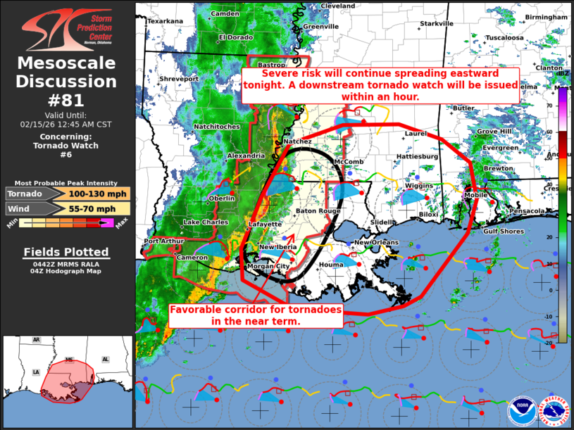
Mesoscale Discussion 0081 NWS Storm Prediction Center Norman OK 1043 PM CST Sat Feb 14 2026 Areas affected...Parts of southern LA...southern MS...and far southwestern AL Concerning...Tornado Watch 6... Valid 150443Z - 150645Z The severe weather threat for Tornado Watch 6 continues. SUMMARY...A heightened tornado risk is evident over parts of southern Louisiana into southwestern Mississippi in the near term -- within Tornado Watch #6. A downstream tornado watch will be issued within an hour. DISCUSSION...A squall line with embedded mesovorticies and supercell structures is tracking eastward across southern LA and southwestern MS tonight. The line is impinging on a corridor of middle/upper 60s dewpoints, which is yielding weakly unstable inflow for these storms. However, the low-level mass response accompanying an approaching midlevel trough continues to favor a 40-50 kt low-level jet and ample low-level hodograph curvature (around 350-400 m2/s2 0-1 km SRH per regional VWP). Given the well-established line of storms and this enhanced low-level helicity, a corridor of heightened tornado potential is evident across parts of southern LA into southwestern MS in the near term, and a strong tornado cannot be entirely ruled out. Thereafter, the squall line will continue eastward along a progressive cold front moving across southeastern LA, southern MS, and far southwestern AL -- where sufficient boundary-layer moisture and strong low/deep-layer shear will support a continued risk of damaging wind gusts and a couple tornadoes. A downstream tornado watch will be issued within an hour for this threat. ..Weinman/Hart.. 02/15/2026 ...Please see www.spc.noaa.gov for graphic product... ATTN...WFO...MOB...JAN...LIX...LCH... LAT...LON 29919212 30759176 31609125 31909026 31918920 31678840 31288789 30708778 30158795 29168882 29008914 28888979 28959113 29419208 29919212 MOST PROBABLE PEAK TORNADO INTENSITY...100-130 MPH MOST PROBABLE PEAK WIND GUST...55-70 MPH |
|
|
Top/All Mesoscale Discussions/Forecast Products/Home |
|
Source link