| Mesoscale Discussion 77 | |
| < Previous MD | |

|
|
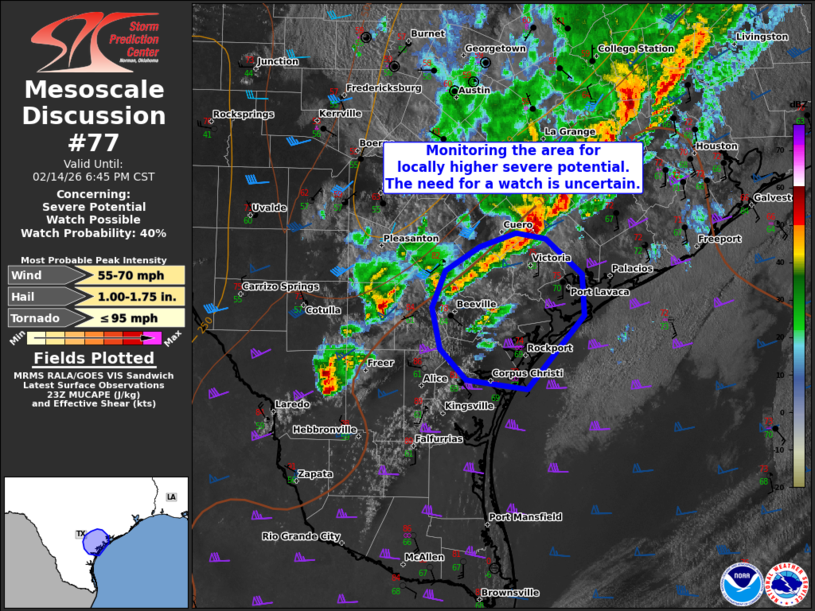
   Mesoscale Discussion 0077
   NWS Storm Prediction Center Norman OK
   0515 PM CST Sat Feb 14 2026

   Areas affected...Parts of the Middle Texas Coast and vicinity

   Concerning...Severe potential...Watch possible

   Valid 142315Z - 150045Z

   Probability of Watch Issuance...40 percent

   SUMMARY...The area is being monitored for locally higher severe
   potential. The main concerns would be severe hail and locally
   damaging gusts. The need for a watch is uncertain.

   DISCUSSION...Convection is gradually increasing along/behind the
   tail end of a composite outflow boundary/cold front moving toward
   the Middle Texas Coast, with additional weak warm-advection-driven
   development in the warm sector. As a robust midlevel jet impinges on
   the area, a continued increase in development is expected during the
   next couple hours. It is possible that storms continue to be focused
   on the cool side of the outflow boundary/front, and remain slightly
   elevated as they approach the coast. Nevertheless, the strengthening
   large-scale ascent, around 60 kt of effective shear, and 1500 J/kg
   MUCAPE may favor organized clusters and supercell structures --
   posing a risk of severe hail and locally damaging gusts. It is
   unclear if a targeted watch is needed, though trends are being
   monitored.

   ..Weinman/Hart.. 02/14/2026

   ...Please see www.spc.noaa.gov for graphic product...

   ATTN...WFO...HGX...CRP...EWX...

   LAT...LON   27809763 28079788 28429796 28749783 28969750 29089713
               29029684 28729649 28369646 27719703 27809763

   MOST PROBABLE PEAK TORNADO INTENSITY...UP TO 95 MPH
   MOST PROBABLE PEAK WIND GUST...55-70 MPH
   MOST PROBABLE PEAK HAIL SIZE...1.00-1.75 IN
|
|
|
Top/All Mesoscale Discussions/Forecast Products/Home |
|
Source link