| Mesoscale Discussion 75 | |
| < Previous MD | |

|
|
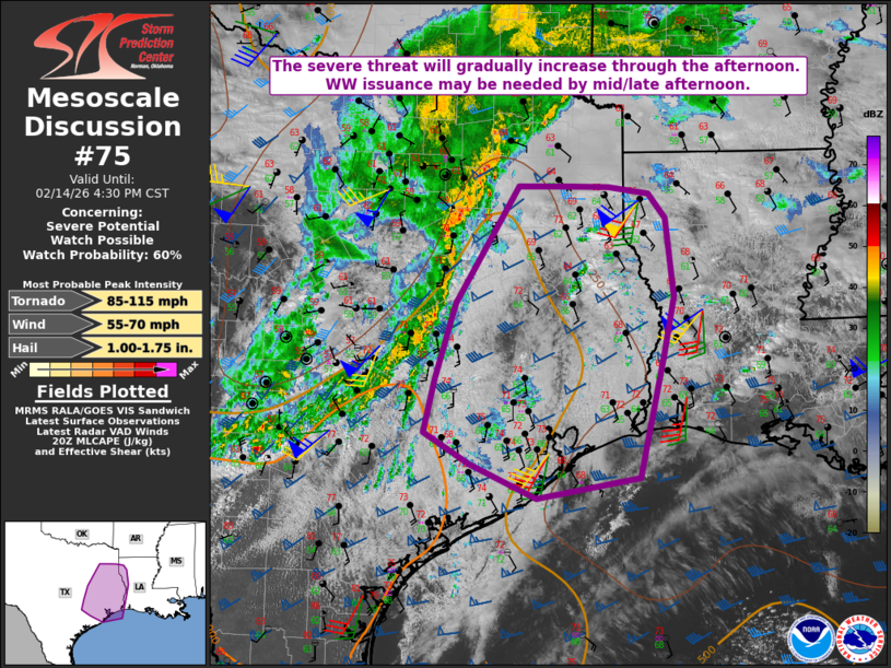
   Mesoscale Discussion 0075
   NWS Storm Prediction Center Norman OK
   0205 PM CST Sat Feb 14 2026

   Areas affected...Parts of east TX into western LA

   Concerning...Severe potential...Watch possible

   Valid 142005Z - 142230Z

   Probability of Watch Issuance...60 percent

   SUMMARY...The severe threat is expected to gradually increase
   through the afternoon. Watch issuance may eventually be needed,
   though timing is uncertain.

   DISCUSSION...A loosely organized QLCS has developed across parts of
   north-central TX early this afternoon, with occasional weak
   low-level rotation noted along the leading edge of the line. Weak
   buoyancy and poor low-level lapse rates have likely limited the
   severe threat thus far across north TX, while a persistent capping
   inversion (noted on the 18Z CRP/LCH soundings and a special College
   Station sounding) has inhibited development of deep convection
   farther south into central TX. However, increasing ascent associated
   with an approaching mid/upper shortwave trough and filtered diurnal
   heating are expected to weaken the cap and gradually increase
   warm-sector buoyancy with time. An increase in storm coverage and
   organization is still expected by late afternoon along the composite
   outflow/cold front, as convection approaches east TX.

   Area VWPs generally depict gradually strengthening low-level flow
   and enlarging hodographs, and this trend is expected to continue as
   low-level mass response increases and a surface low begins to
   consolidate and deepen near the ArkLaTex by late afternoon/early
   evening. The strengthening ascent and effective SRH may result in
   development of a more organized QLCS across parts of east/southeast
   TX by late afternoon. While questions remain regarding the impact of
   poor low-level lapse rates (as noted on the 18Z SHV sounding) on the
   north and east extent of the severe threat, gradually increasing
   damaging-wind and line-embedded tornado potential may necessitate
   watch issuance by mid to late afternoon.

   ..Dean/Gleason.. 02/14/2026

   ...Please see www.spc.noaa.gov for graphic product...

   ATTN...WFO...LCH...SHV...HGX...FWD...EWX...

   LAT...LON   32619549 32629478 32619424 32539369 32249346 31309336
               30599350 29189384 28949524 29339613 29719677 30359662
               31229634 32619549

   MOST PROBABLE PEAK TORNADO INTENSITY...85-115 MPH
   MOST PROBABLE PEAK WIND GUST...55-70 MPH
   MOST PROBABLE PEAK HAIL SIZE...1.00-1.75 IN
|
|
|
Top/All Mesoscale Discussions/Forecast Products/Home |
|
Source link