| Mesoscale Discussion 73 | |
| < Previous MD | |

|
|
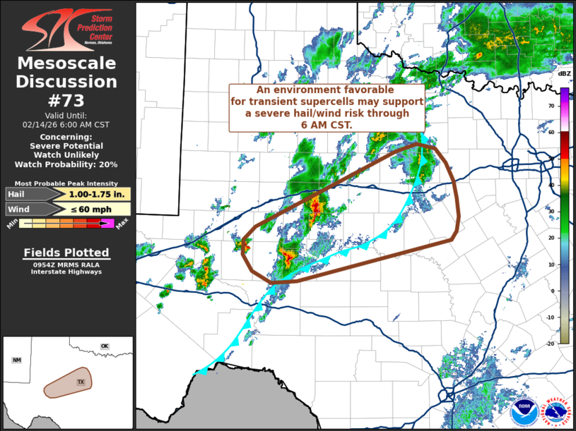
   Mesoscale Discussion 0073
   NWS Storm Prediction Center Norman OK
   0357 AM CST Sat Feb 14 2026

   Areas affected...Western to central Texas

   Concerning...Severe potential...Watch unlikely

   Valid 140957Z - 141200Z

   Probability of Watch Issuance...20 percent

   SUMMARY...A corridor favorable for weak supercells may persist
   across portions of western to central Texas through 6 AM CST. Watch
   issuance is not expected.

   DISCUSSION...Intensification of maturing supercells is noted in
   recent MRMS and GOES imagery to the north and west of the San
   Angelo, TX area. These cells are becoming established within a
   somewhat narrow mesoscale corridor where low-level warm/moist
   advection is overriding cold pools established by prior
   precipitation/convection, which is maintaining MUCAPE values between
   approximately 500-1000 J/kg. Persistent deep-layer ascent within the
   warm air advection regime and ahead of the approaching upper wave,
   coupled with strong flow aloft (60-70 knots between 6-8 km per the
   KSJT VWP), should maintain a corridor favorable for supercell
   development. Based on recent MRMS estimates, these cells should be
   capable of producing severe hail (most likely up to 1.5 inches in
   diameter) and isolated strong to severe gusts. Undulation in the
   vertically integrated ice fields associated with the deeper
   convective cores casts some uncertainty onto the longevity of any
   individual cells, but this favorable mesoscale corridor may persist
   across the region through roughly 6 AM CST.

   ..Moore/Smith.. 02/14/2026

   ...Please see www.spc.noaa.gov for graphic product...

   ATTN...WFO...FWD...SJT...MAF...

   LAT...LON   31450194 31680194 31870173 32989934 33089896 33019864
               32809846 32539833 32289828 32029825 31819829 31689839
               31080102 31040146 31210179 31450194

   MOST PROBABLE PEAK WIND GUST...UP TO 60 MPH
   MOST PROBABLE PEAK HAIL SIZE...1.00-1.75 IN
|
|
|
Top/All Mesoscale Discussions/Forecast Products/Home |
|
Source link