| Mesoscale Discussion 724 | |
| < Previous MD | |

|
|
Mesoscale Discussion 0724
NWS Storm Prediction Center Norman OK
0234 PM CDT Fri May 15 2026
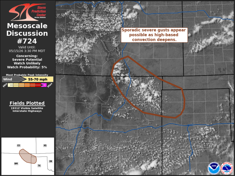
Areas affected...Far southern Colorado...northeast New Mexico and
Portions of the Oklahoma/Texas Panhandles
Concerning...Severe potential...Watch unlikely
Valid 151934Z - 152130Z
Probability of Watch Issuance...5 percent
SUMMARY...High-based convection developing across portions of the
southern High Plains may pose a risk of strong to severe downburst
winds through early evening. Watch issuance is not expected given
the short-lived and spatially limited nature of this threat.
DISCUSSION...Deepening cumulus is noted in recent GOES imagery along
the Raton Mesa and southeastward towards the far northwest TX
Panhandle. Continued weak upslope flow and low-level convergence
along a trough axis should promote further convective development
through the afternoon as temperatures climb into the low 90s and
SBCAPE values increase to around 500 J/kg. Very weak mid-level flow
will limit storm organization and longevity; however, a very deeply
mixed boundary layer (LCLs estimated to be around 3.5 to 4 km AGL)
will promote evaporative cooling and downdraft acceleration of even
modestly deep convective cores. Consequently, sporadic bursts of
strong to severe winds appear possible as convection evolves over
the next few hours. Given the poor kinematic environment, this
threat will most likely be too short-lived and spatially confined to
warrant watch issuance.
..Moore/Guyer.. 05/15/2026
...Please see www.spc.noaa.gov for graphic product...
ATTN...WFO...AMA...PUB...ABQ...
LAT...LON 35510288 35670386 35950435 36300478 36810520 37070531
37410519 37610491 37720456 37490416 37200367 36900312
36700259 36530213 36130201 35810204 35610219 35480244
35510288
MOST PROBABLE PEAK WIND GUST...55-70 MPH
|
|
|
Top/All Mesoscale Discussions/Forecast Products/Home |
|
Source link