|
|
| Mesoscale Discussion 642 | |
| < Previous MD | |

|
|
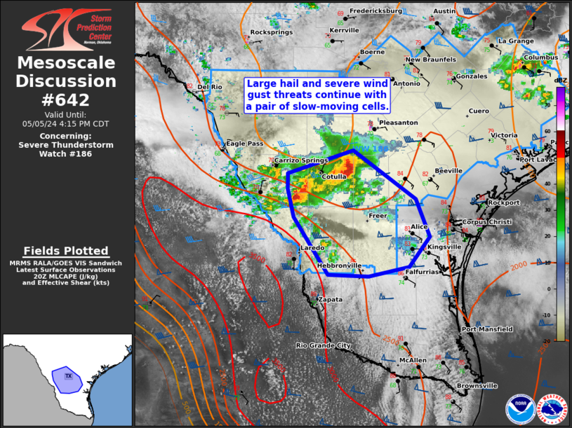
Mesoscale Discussion 0642 NWS Storm Prediction Center Norman OK 0309 PM CDT Sun May 05 2024 Areas affected...South TX Concerning...Severe Thunderstorm Watch 186... Valid 052009Z - 052115Z The severe weather threat for Severe Thunderstorm Watch 186 continues. SUMMARY...A couple of supercells embedded within a slow, southeast-moving cluster will largely impact the southwest portion of WW 186 through 6 PM CDT. Additional severe storm development will be possible elsewhere, but appears to be trending towards lower probabilities of occurrence. DISCUSSION...A pair of deep convective updrafts with echo tops of 50-55k ft are slowly moving southeastward at around 15 kts. These cells appear to have connected outflow and will likely continue their slow progression over the next couple hours. The environment ahead of them contains appreciable buoyancy with MLCAPE of 2000-2500 J/kg, supporting a potential increase in intensity through late afternoon with a mix of large hail to around golf ball size and wind gusts of 55-70 mph possible. With greater MLCIN over Deep South TX, in conjunction with increasing mid-level warming in the wake of a southern-stream low-amplitude shortwave impulse, the severe threat should decrease during the early evening. Farther north and northeast, convection has largely struggled to intensify along residual outflows where the boundary layer has been relatively cooler. 18Z HRRR guidance suggests this activity may not greatly intensify, and the overall severe threat appears marginal. ..Grams.. 05/05/2024 ...Please see www.spc.noaa.gov for graphic product... ATTN...WFO...CRP...EWX...BRO... LAT...LON 28709880 28129798 27699780 27349806 27239859 27259913 27919958 28249965 28429966 28709880 |
|
|
Top/All Mesoscale Discussions/Forecast Products/Home |
|


