|
|
| Mesoscale Discussion 639 | |
| < Previous MD | |

|
|
   Mesoscale Discussion 0639
   NWS Storm Prediction Center Norman OK
   1202 PM CDT Sun May 05 2024

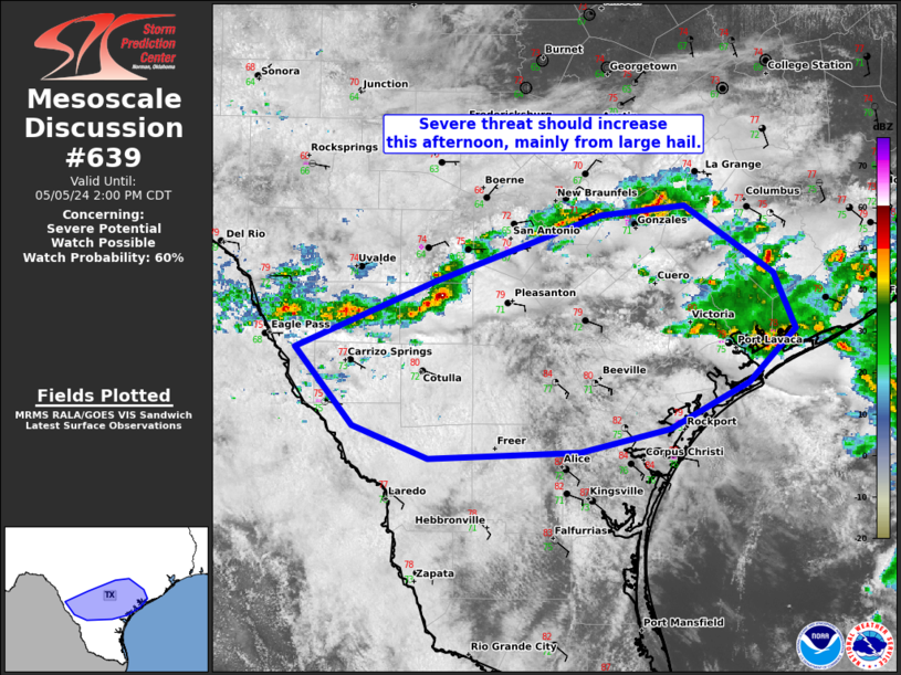
   Areas affected...South-central TX

   Concerning...Severe potential...Watch possible

   Valid 051702Z - 051900Z

   Probability of Watch Issuance...60 percent

   SUMMARY...Ongoing convection should intensify across parts of
   south-central Texas at some point this afternoon. Primary threat
   should be from large hail between 1.5 to 2.5 inches in diameter.
   Localized severe wind gusts and a brief tornado will also be
   possible. Timing of severe storms beyond isolated coverage is
   somewhat uncertain.

   DISCUSSION...Ongoing convection exists from Maverick to Fayette
   counties in south-central TX and separately along the Middle TX
   coast. Ascent tied to a low-amplitude shortwave impulse that is
   moving northeast and recently crossed the Rio Grande will be
   maximized over the next few hours. Sufficient cloud breaks have
   yielded temperatures generally in the low to mid 80s within the very
   richly moist boundary layer ahead of the ongoing storms. This will
   support a continued plume of moderate buoyancy with MLCAPE of
   1500-2500 J/kg, despite mid-level warming being well-progged to
   occur in the wake of the shortwave impulse as it moves across the
   area. Pronounced veering of the low-level wind profile with height
   will also compensate for modest lower-level speeds and should
   support at least transient supercell structures, with a primary
   hazard of isolated large hail. Given the buoyancy profile, a
   supercell or two may be longer-lasting, albeit slow-moving to the
   southeast, as seemingly simulated by late morning HRRR and 12Z
   NSSL-MPAS guidance. The less-than-ideal timing of large-scale ascent
   does render uncertainty over the degree of severe storm coverage, as
   well as longevity, especially towards early evening.

   ..Grams/Smith.. 05/05/2024

   ...Please see www.spc.noaa.gov for graphic product...

   ATTN...WFO...HGX...CRP...EWX...

   LAT...LON   29099911 29589773 29669703 29169629 28759612 28359650
               28019716 27849790 27799917 28049979 28610028 29099911
|
|
|
Top/All Mesoscale Discussions/Forecast Products/Home |
|


