| Mesoscale Discussion 638 | |
| < Previous MD | |
|
|
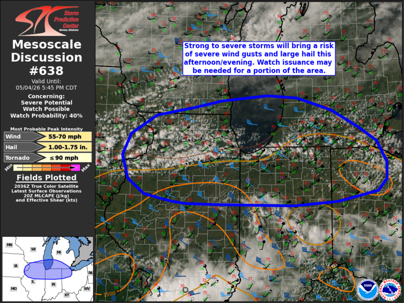
   Mesoscale Discussion 0638
   NWS Storm Prediction Center Norman OK
   0342 PM CDT Mon May 04 2026

   Areas affected...portions of the Midwest and southern Great Lakes

   Concerning...Severe potential...Watch possible

   Valid 042042Z - 042245Z

   Probability of Watch Issuance...40 percent

   SUMMARY...Widely scattered to scattered thunderstorm development is
   expected late this afternoon, with potential for severe/damaging
   wind gusts and large hail. Watch issuance is possible for a portion
   of the discussion area.

   DISCUSSION...Prevailing southwesterly flow has yielded modest
   moisture return across portions of the Midwest into the southern
   Great Lakes region, with dewpoints climbing into the 40s/low-50s.
   While a surface cold front remains displaced to the northwest,
   expectation is for widely scattered to scattered strong to severe
   thunderstorms to develop within the warm conveyor this afternoon as
   convective temperatures are reached and remaining inhibition is
   removed. A 700-mb speed max associated with an approaching shortwave
   trough will help to promote 30-40 kts of effective bulk shear across
   the region, with MLCAPE forecast in the 500-1250 J/kg range. This
   will be sufficient to support storm organization into
   multicells/clusters and perhaps transient supercell structures;
   although, the lack stronger flow aloft and limited hodograph
   elongation is likely to limit supercell intensity/persistence.

   Dry mid-level air and well-mixed boundary layers (as sampled by
   regional ACARS profiles and the 18z DVN observed sounding) will
   support a risk for severe/damaging wind gusts. Large hail will also
   be possible given modestly steep mid-level lapse rates (>7 C/km per
   latest mesoanalysis). While a strengthening of 850 mb flow and some
   accompanying increase in low-level hodograph curvature is expected
   this evening (especially across northern Indiana and northwest Ohio
   within the 21-00z time frame), the tornado threat remains uncertain
   owing to the expectation for boundary layer moisture quality to
   remain more limited across the region.

   Thus, given the potential for these hazards, a Severe Thunderstorm
   Watch is possible for a portion of the discussion area, particularly
   from northeastern Illinois into northwestern Ohio where the
   potential coverage of severe hazards appears greater.

   ..Chalmers/Smith.. 05/04/2026

   ...Please see www.spc.noaa.gov for graphic product...

   ATTN...WFO...CLE...ILN...DTX...IWX...GRR...IND...LOT...ILX...
   MKX...DVN...

   LAT...LON   40518958 40679037 41009087 41529106 42019081 42459004
               42658882 42808808 42928668 42858577 42578475 42178393
               41858341 41368312 40998314 40728341 40518462 40438591
               40448725 40458834 40478912 40518958

   MOST PROBABLE PEAK TORNADO INTENSITY...UP TO 90 MPH
   MOST PROBABLE PEAK WIND GUST...55-70 MPH
   MOST PROBABLE PEAK HAIL SIZE...1.00-1.75 IN
|
|
|
Top/All Mesoscale Discussions/Forecast Products/Home |
|
Source link