| Mesoscale Discussion 630 | |
| < Previous MD | |

|
|
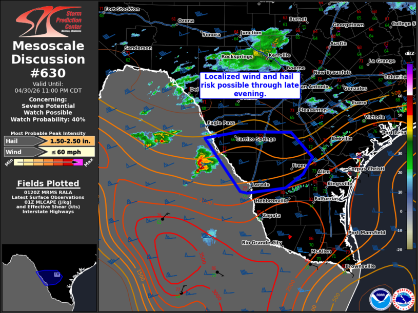
   Mesoscale Discussion 0630
   NWS Storm Prediction Center Norman OK
   0823 PM CDT Thu Apr 30 2026

   Areas affected...portions of southwestern and south-central Texas

   Concerning...Severe potential...Watch possible

   Valid 010123Z - 010400Z

   Probability of Watch Issuance...40 percent

   SUMMARY...A localized wind and large hail threat will be possible
   through late this evening as supercells move out of Mexico across
   the Rio Grande.

   DISCUSSION...Storms are noted to be occasionally intense on
   satellite and radar across the eastern Sierra Madre in Mexico this
   evening. Hi-res CAM guidance suggests that a few of these storms may
   persist and move across the Rio Grande into the Edwards Plateau
   region and perhaps portions of south-central Texas. The air mass
   across southern Texas is moderately unstable with strong deep layer
   shear ahead of the ejecting wave to the west across Baja California.
   Storms would likely be elevated in nature, given diurnal inversion
   layer, with the main hazards being large hail and strong to severe
   wind. Given some uncertainty in thunderstorm maintenance and the
   localized nature of this threat, a watch remains uncertain. Trends
   will be monitored through the evening.

   ..Thornton/Hart.. 05/01/2026

   ...Please see www.spc.noaa.gov for graphic product...

   ATTN...WFO...CRP...EWX...

   LAT...LON   28480052 28609975 28609861 28119815 27789836 27509875
               27409958 27449973 28480052

   MOST PROBABLE PEAK WIND GUST...UP TO 60 MPH
   MOST PROBABLE PEAK HAIL SIZE...1.50-2.50 IN
|
|
|
Top/All Mesoscale Discussions/Forecast Products/Home |
|
Source link