| Mesoscale Discussion 626 | |
| < Previous MD | |

|
|
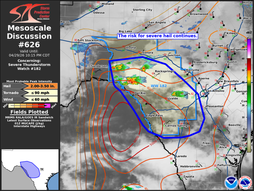
Mesoscale Discussion 0626 NWS Storm Prediction Center Norman OK 0839 PM CDT Wed Apr 29 2026 Areas affected...southwest Texas Concerning...Severe Thunderstorm Watch 182... Valid 300139Z - 300315Z The severe weather threat for Severe Thunderstorm Watch 182 continues. SUMMARY...Isolate to widely scattered elevated supercells will continue to pose a risk for severe hail this evening. DISCUSSION...As of 0135 UTC, regional radar analysis showed several new storms had developed across WW182 in the last two hours. Organization has been noted with several of these storms displaying fairly strong mid-level rotation. These storms are likely elevated, north of the sagging front/outflow. Still, a broad reservoir of elevated buoyancy remains in place across southwest TX with 3000-5000 J/kg of MUCAPE and steep mid-level lapse rates (DRT/MAF RAOBs). Effective shear is also robust with 50-60 kt of deep-layer zonal flow overspreading the region. This should continue to support supercells with significant hail potential (2-3") along the Rio Grande Valley and Southwest TX this evening. ..Lyons.. 04/30/2026 ...Please see www.spc.noaa.gov for graphic product... ATTN...WFO...CRP...EWX...SJT...MAF... LAT...LON 30370175 30490060 30299982 29849924 29399871 28679852 28299869 28179903 28129929 28119988 28180006 28300040 28490059 28920088 29470135 29600153 29670158 30370175 MOST PROBABLE PEAK TORNADO INTENSITY...UP TO 90 MPH MOST PROBABLE PEAK WIND GUST...UP TO 60 MPH MOST PROBABLE PEAK HAIL SIZE...2.00-3.50 IN |
|
|
Top/All Mesoscale Discussions/Forecast Products/Home |
|
Source link