| Mesoscale Discussion 624 | |
| < Previous MD | |

|
|
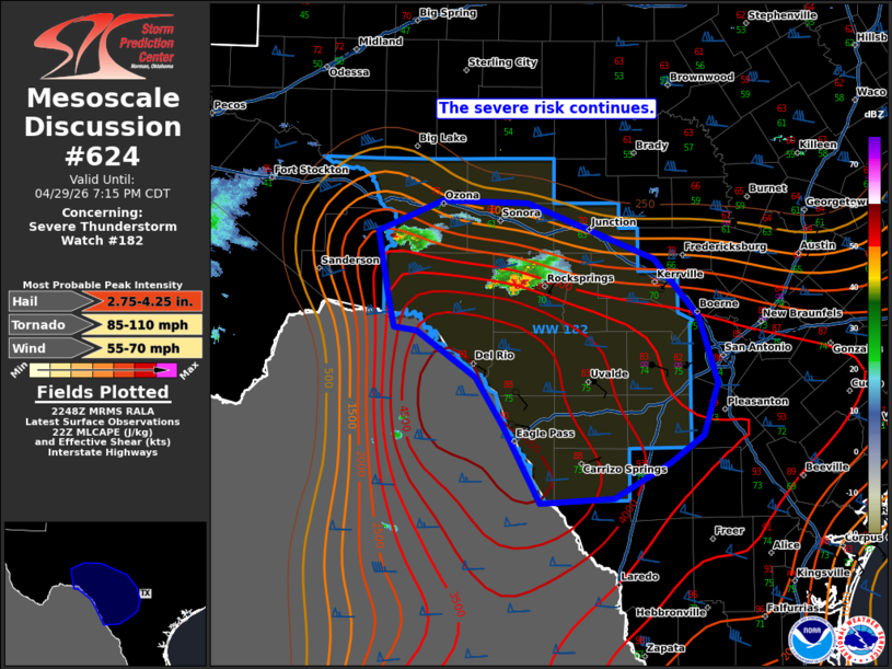
Mesoscale Discussion 0624 NWS Storm Prediction Center Norman OK 0550 PM CDT Wed Apr 29 2026 Areas affected...portions of western and central Texas Concerning...Severe Thunderstorm Watch 182... Valid 292250Z - 300015Z The severe weather threat for Severe Thunderstorm Watch 182 continues. SUMMARY...The severe risk (primarily for large hail) continues across WW182 this evening. DISCUSSION...A cluster of storms remains ongoing along the modified outflow/cold front in northern portions of WW182. So far, these storms have remained on the cool side of the slowly sagging boundary with little intensification noted. Still, some storm-scale rotation and presence of large MUCAPE (3000-4000 J/kg) amid favorable deep-layer shear for supercells will support severe potential, mainly in the form of large to very large hail. An uptick in severe potential could occur if these storms are able to move onto the warm side of the boundary. This would also support some risk for an isolated tornado and damaging gusts, but this remains uncertain. Additional development has been noted farther northwest along the boundary into Terrell and Crockett Counties. CAM guidance and observational trends suggest a similar severe risk is possible with these storms as they mature this evening. Given the extremely unstable and strongly sheared environment, the severe risk continues across WW182. ..Lyons.. 04/29/2026 ...Please see www.spc.noaa.gov for graphic product... ATTN...WFO...CRP...EWX...SJT...MAF... LAT...LON 30720120 30700036 30239915 29759872 29199853 28749867 28519899 28229954 28180025 28830060 29230087 29630144 29660166 29930172 30470182 30720120 MOST PROBABLE PEAK TORNADO INTENSITY...85-110 MPH MOST PROBABLE PEAK WIND GUST...55-70 MPH MOST PROBABLE PEAK HAIL SIZE...2.75-4.25 IN |
|
|
Top/All Mesoscale Discussions/Forecast Products/Home |
|
Source link