| Mesoscale Discussion 622 | |
| < Previous MD | |

|
|
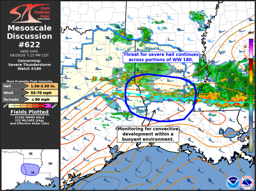
Mesoscale Discussion 0622 NWS Storm Prediction Center Norman OK 0520 PM CDT Wed Apr 29 2026 Areas affected...central Louisiana and far eastern Texas Concerning...Severe Thunderstorm Watch 180... Valid 292220Z - 300015Z The severe weather threat for Severe Thunderstorm Watch 180 continues. SUMMARY...Some risk of severe hail, and perhaps damaging winds, persists across portions of WW 180 in central Louisiana. Additionally, conditions are being monitored along and south of an outflow boundary for additional development within a buoyant air mass. DISCUSSION...Organized convection with a history of producing severe hail continues to traverse far eastern TX and western LA. Although this activity will likely remain elevated behind a surface front/outflow boundary, the downstream environment continues to feature sufficient MUCAPE (around 1500 J/kg) and deep-layer wind shear for organized convection, including the potential for elevated supercells. Consequently, the primary hazard will most likely be large hail (most likely in the 1 to 1.75 inch range, though hail stones up to 2 inches appear possible given favorably weak low-level shear and strong flow aloft). Sporadic damaging winds also appear possible given the relatively warm (albeit still stable) surface conditions. Further south, trends are being monitored as new convection attempts to develop along and ahead of the front/outflow boundary. Convection developing towards the south will mature in a similarly favorable environment and will pose a severe hail threat. New convection may develop to the south of the current bounds of WW 180 depending on the southward propagation of the outflow. If this occurs, downstream watch issuance may be needed. ..Moore.. 04/29/2026 ...Please see www.spc.noaa.gov for graphic product... ATTN...WFO...JAN...LIX...LCH...SHV... LAT...LON 32289383 32339351 32189216 32109188 31949158 31679149 31099161 30969173 30719200 30649259 30659302 30739343 30819386 30979419 31279438 31619443 31819442 31999436 32209414 32289383 MOST PROBABLE PEAK TORNADO INTENSITY...UP TO 90 MPH MOST PROBABLE PEAK WIND GUST...55-70 MPH MOST PROBABLE PEAK HAIL SIZE...1.50-2.50 IN |
|
|
Top/All Mesoscale Discussions/Forecast Products/Home |
|
Source link