|
|
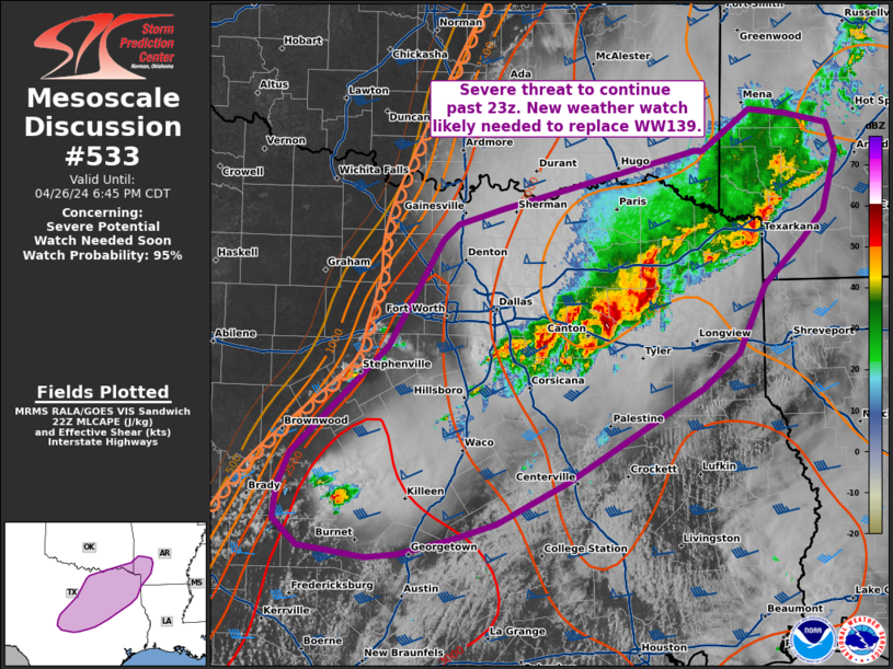
| Mesoscale Discussion 533 | |
| < Previous MD | |
|
|
Mesoscale Discussion 0533 NWS Storm Prediction Center Norman OK 0555 PM CDT Wed Apr 23 2025 Areas affected...TX Trans-Pecos/Permian Basin into extreme southeast NM Concerning...Severe Thunderstorm Watch 162... Valid 232255Z - 240030Z The severe weather threat for Severe Thunderstorm Watch 162 continues. SUMMARY...Isolated severe storms may persist through the evening. DISCUSSION...Widely scattered strong to severe storms are ongoing as of 2245 UTC across the TX Trans-Pecos region. The most intense ongoing storm is a left-moving supercell moving northward to the west of Wink, TX. This cell may persist into southeast NM, as it moves along a north-south oriented instability gradient into early evening. Favorable lapse rates/buoyancy and sufficient deep-layer shear will result in a threat of large hail for as long as this cell persists, with a conditional threat of hail larger than golf balls. Strong to severe outflow gusts will also be possible within the relatively well-mixed environment. Farther south, convection has struggled to maintain severe intensity, with somewhat cooler temperatures and stronger MLCINH noted in the vicinity of the cell west of Fort Stockton. However, deep-layer shear increases with southward extent due to the presence of a subtropical jet, and the environment remains conditionally favorable for supercells and an attendant severe hail/wind threat if any updrafts can be sustained. Also, locally backed flow and somewhat richer low-level moisture could support some tornado potential if any supercell can be sustained in the region near/south of Fort Stockton. ..Dean.. 04/23/2025 ...Please see www.spc.noaa.gov for graphic product... ATTN...WFO...MAF... LAT...LON 30050448 31720379 32840349 32880274 31270247 29830254 29200274 29040314 29080367 29240400 29520440 30050448 MOST PROBABLE PEAK TORNADO INTENSITY...85-115 MPH MOST PROBABLE PEAK WIND GUST...65-80 MPH MOST PROBABLE PEAK HAIL SIZE...1.50-2.50 IN |
|
|
Top/All Mesoscale Discussions/Forecast Products/Home |
|
Source link