|
|
| Mesoscale Discussion 451 | |
| < Previous MD | |
|
|
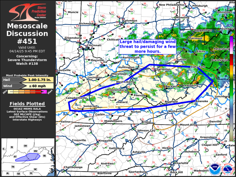
Mesoscale Discussion 0451 NWS Storm Prediction Center Norman OK 0718 PM CDT Mon Apr 14 2025 Areas affected...eastern Kentucky...southern West Virginia...and far western Virginia Concerning...Severe Thunderstorm Watch 138... Valid 150018Z - 150145Z The severe weather threat for Severe Thunderstorm Watch 138 continues. SUMMARY...A large hail/damaging wind threat will persist for a few more hours this evening. DISCUSSION...A cluster of supercells across central West Virginia has weakened over the past hour, but are still capable of some large hail and damaging wind gusts for a few more hours. The greatest threat will likely be with new development farther south and west where a deeply-mixed airmass is present with greater instability. However, even in this area the threat will likely only persist for a few more hours given the loss of daytime heating. ..Bentley.. 04/15/2025 ...Please see www.spc.noaa.gov for graphic product... ATTN...WFO...LWX...RNK...RLX...MRX...JKL...LMK... LAT...LON 37278519 37788380 38008289 38578182 38457979 37977916 37357993 37098212 36998474 37008512 37278519 MOST PROBABLE PEAK WIND GUST...UP TO 60 MPH MOST PROBABLE PEAK HAIL SIZE...1.00-1.75 IN |
|
|
Top/All Mesoscale Discussions/Forecast Products/Home |
|
Source link