| Mesoscale Discussion 423 | |
| < Previous MD | |
|
|
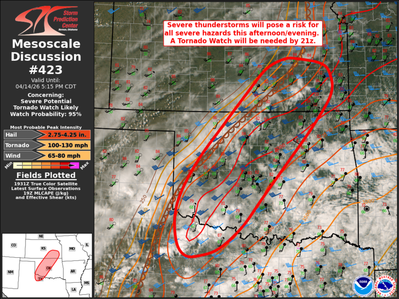
   Mesoscale Discussion 0423
   NWS Storm Prediction Center Norman OK
   0239 PM CDT Tue Apr 14 2026

   Areas affected...portions of northwest Texas into central Oklahoma
   and southern Kansas

   Concerning...Severe potential...Tornado Watch likely

   Valid 141939Z - 142215Z

   Probability of Watch Issuance...95 percent

   SUMMARY...Severe thunderstorms expected to develop along a dryline
   this afternoon will bring the potential for all severe hazards. A
   Tornado Watch will be needed by 21z.

   DISCUSSION...Latest surface analysis depicts a dryline extending
   from eastern Kansas southwestward into northwest Oklahoma and the
   southeastern Texas Panhandle. Enhanced southwesterly flow aloft
   (40-50+ kts at 4-5 km AGL per regional VWPs) and modest ascent
   preceding an approaching upper-level trough will overspread the warm
   sector through the afternoon. Steep mid-level lapse rates (per the
   12Z OUN/FWD/MAF soundings) atop surface temperatures in the low-80s
   and dewpoints in the mid/upper-60s F are supporting strong
   instability (MLCAPE 2500-3000+ J/kg) ahead of the dryline, with
   convective initiation expected within the next 1-2 hours as
   convective temperatures are reached.

   35-45 kts of effective bulk shear (per latest mesoanalysis) will
   support initial supercells, with very large to giant hail (up to 3-4
   inches in diameter) likely given the aforementioned steep mid-level
   lapse rates, ample buoyancy within the hail growth zone, and
   elongated hodographs. A few tornadoes (some potentially strong) are
   also possible, especially with any supercells that can remain
   largely discrete into the evening hours when a strengthening
   nocturnal low-level jet will yield enlarged, clockwise-curved
   low-level hodographs. A Tornado Watch will be needed by 21z to cover
   this threat.

   Expectation is then for upscale growth to gradually occur with time
   this evening, with a transition toward severe wind gusts as the
   primary threat.

   ..Chalmers/Gleason.. 04/14/2026

   ...Please see www.spc.noaa.gov for graphic product...

   ATTN...WFO...TSA...TOP...ICT...OUN...

   LAT...LON   34149793 33619861 33429920 33429958 33719984 34359992
               34969976 35809926 36689849 37499774 38069716 38309660
               38309618 38179544 37919519 37439517 36679571 35419683
               34829735 34149793

   MOST PROBABLE PEAK TORNADO INTENSITY...100-130 MPH
   MOST PROBABLE PEAK WIND GUST...65-80 MPH
   MOST PROBABLE PEAK HAIL SIZE...2.75-4.25 IN
|
|
|
Top/All Mesoscale Discussions/Forecast Products/Home |
|
Source link