| Mesoscale Discussion 421 | |
| < Previous MD | |

|
|
   Mesoscale Discussion 0421
   NWS Storm Prediction Center Norman OK
   0124 PM CDT Tue Apr 14 2026

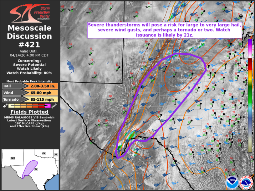
   Areas affected...portions of the Texas Big Bend and Edwards Plateau
   into Northwest Texas

   Concerning...Severe potential...Watch likely

   Valid 141824Z - 142100Z

   Probability of Watch Issuance...80 percent

   SUMMARY...Thunderstorms developing along/ahead of a dryline this
   afternoon will pose a risk for large to very large hail and perhaps
   a tornado or two. A watch will likely be needed within the next
   couple of hours.

   DISCUSSION...Latest regional radar imagery and GLM Flash data
   indicate ongoing thunderstorm development across the Chisos
   Mountains within the Texas Big Bend region. Additional thunderstorm
   development is expected this afternoon along a dryline across much
   of West Texas and across the Sierra del Carmen in northern Mexico.
   Ahead of this dryline, surface temperatures in the low/mid-80s F and
   dewpoints in the mid-60s F underneath steep mid-level lapse rates
   are supporting 1500-2500 J/kg MLCAPE (locally greater). Effective
   bulk shear of 35-45+ kts and straight, elongated hodographs will
   support supercells (both left- and right-moving) capable of large to
   very large hail of 2-3+ inches in diameter and severe wind gusts. A
   gradually strengthening nocturnal low-level jet will likely support
   at least some increase in the tornado threat later this evening,
   especially with any persistent, discrete supercell(s); however, the
   core of the low-level jet is forecast to be displaced farther to the
   northeast. Thus, the magnitude of the tornado threat remains
   somewhat uncertain at this time. Regardless, watch issuance will
   likely be needed by 21z.

   With time, some gradual upscale growth/clustering should occur with
   ongoing storms, with an associated increase in the potential for
   severe wind gusts.

   ..Chalmers/Gleason.. 04/14/2026

   ...Please see www.spc.noaa.gov for graphic product...

   ATTN...WFO...FWD...EWX...SJT...LUB...MAF...

   LAT...LON   29240278 29050292 28950320 29200328 29920317 31950219
               32480174 32990115 33240047 33219980 33049926 32809907
               32549902 31809967 31200022 30590082 30160132 29880156
               29650193 29700241 29510262 29240278

   MOST PROBABLE PEAK TORNADO INTENSITY...85-115 MPH
   MOST PROBABLE PEAK WIND GUST...65-80 MPH
   MOST PROBABLE PEAK HAIL SIZE...2.00-3.50 IN
|
|
|
Top/All Mesoscale Discussions/Forecast Products/Home |
|
Source link


