| Mesoscale Discussion 411 | |
| < Previous MD | |

|
|
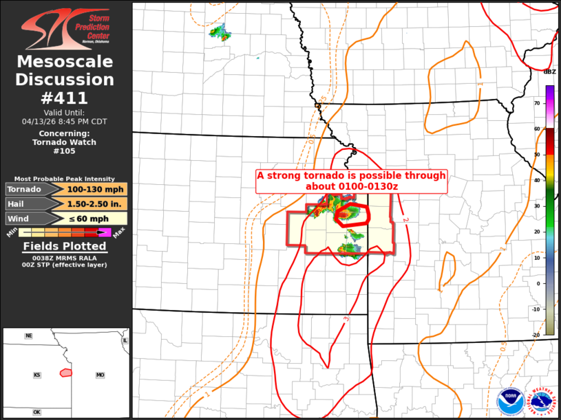
Mesoscale Discussion 0411 NWS Storm Prediction Center Norman OK 0739 PM CDT Mon Apr 13 2026 Areas affected...Eastern Kansas Concerning...Tornado Watch 105... Valid 140039Z - 140145Z The severe weather threat for Tornado Watch 105 continues. SUMMARY...A strong tornado is possible with the sustained supercell in Franklin Co. Kansas through 0100-0130z. DISCUSSION...A supercell has continued to get better organized after a few mergers, and is now a tornadic storm moving into a favorable environment. A strong tornado will be possible given the increasing low-level shear (250-300 0-1km SRH per TWX and EAX VWPs) in a sufficiently moist/buoyant environment this evening. ..Thompson.. 04/14/2026 ...Please see www.spc.noaa.gov for graphic product... ATTN...WFO...EAX...TOP... LAT...LON 38549463 38499514 38619529 38749527 38879498 38829463 38709459 38629459 38549463 MOST PROBABLE PEAK TORNADO INTENSITY...100-130 MPH MOST PROBABLE PEAK WIND GUST...UP TO 60 MPH MOST PROBABLE PEAK HAIL SIZE...1.50-2.50 IN |
|
|
Top/All Mesoscale Discussions/Forecast Products/Home |
|
Source link