| Mesoscale Discussion 410 | |
| < Previous MD | |

|
|
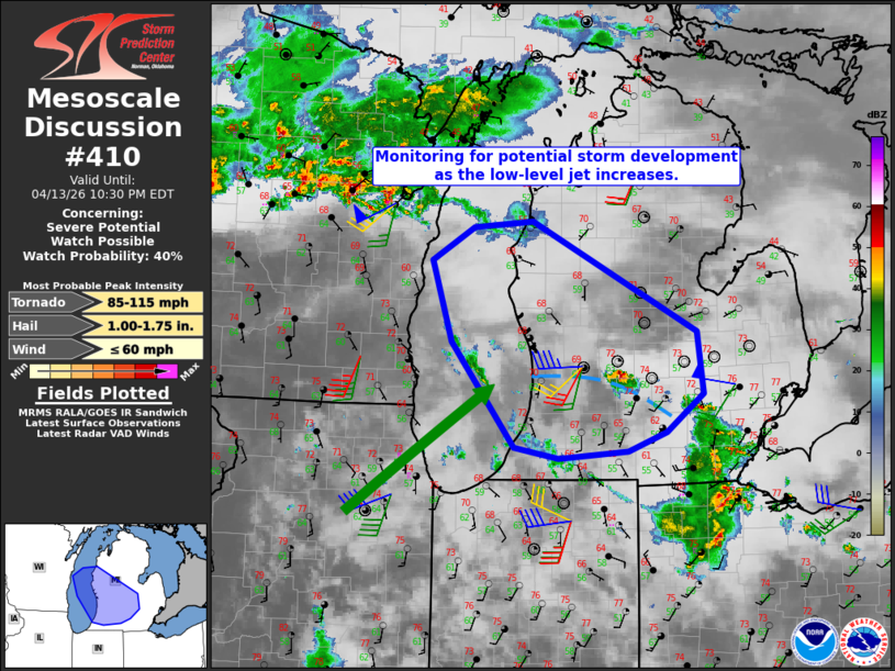
   Mesoscale Discussion 0410
   NWS Storm Prediction Center Norman OK
   0725 PM CDT Mon Apr 13 2026

   Areas affected...Portions central/southern Lower Michigan

   Concerning...Severe potential...Watch possible

   Valid 140025Z - 140230Z

   Probability of Watch Issuance...40 percent

   SUMMARY...An increase in the low-level jet across parts of the lower
   Great Lakes region could initiate storms capable of large hail and
   isolated damaging winds. Convective trends are being monitored for a
   possible watch.

   DISCUSSION...A lone cell has been ongoing west of Lansing along
   outflow from a convective cluster to the south and east. This storm
   has produced marginally severe hail thus far. Lapse rates at
   midlevels were quite steep on the observed DVN sounding (8.2 C/km)
   with diminishing values farther east (observed DTX showed 6.3 C/km).
   During the evening, the low-level jet is forecast to be focused over
   the Upper Midwest, including lower Michigan. There are already signs
   of ascent from northern Illinois into Lake Michigan. With some
   guidance showing additional, intensifying activity evolving over the
   next few hours, these areas are being monitored for a possible
   watch. Large hail and isolated damaging winds would be the primary
   threats. The tornado risk is not as clear as low-level profiles are
   expected to be neutrally stable at best. That said, low-level
   hodographs will be large and theta-e advection will slow nocturnal
   stabilization.

   ..Wendt/Hart.. 04/14/2026

   ...Please see www.spc.noaa.gov for graphic product...

   ATTN...WFO...DTX...APX...IWX...GRR...

   LAT...LON   42228439 42038492 41978586 42088645 43128730 43938757
               44268701 44328620 43238398 42608389 42228439

   MOST PROBABLE PEAK TORNADO INTENSITY...85-115 MPH
   MOST PROBABLE PEAK WIND GUST...UP TO 60 MPH
   MOST PROBABLE PEAK HAIL SIZE...1.00-1.75 IN
|
|
|
Top/All Mesoscale Discussions/Forecast Products/Home |
|
Source link