| Mesoscale Discussion 409 | |
| < Previous MD | |
|
|
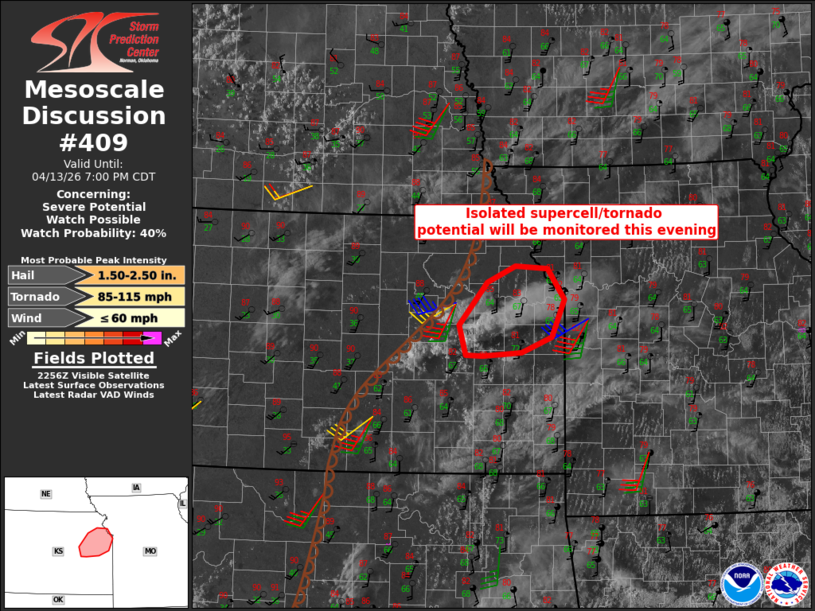
   Mesoscale Discussion 0409
   NWS Storm Prediction Center Norman OK
   0605 PM CDT Mon Apr 13 2026

   Areas affected...Northeast Kansas

   Concerning...Severe potential...Watch possible

   Valid 132305Z - 140000Z

   Probability of Watch Issuance...40 percent

   SUMMARY...There is the potential for a tornadic supercell this
   evening, but storm longevity is in question.

   DISCUSSION...Some supercell structures have been noted with a storm
   that formed earlier southwest of Emporia, though this storm has
   struggled some to maintain intensity.  More recent attempts at
   updrafts south-through-west of this initial storm could lead to
   mergers and some potential for a sufficiently large/deep storm to
   take advantage of the downstream environment.  If a sustained storm
   emerges over northeast KS the next 1-2 hours, downstream dewpoints
   in the upper 60s and enlarging low-level hodographs this evening
   will support tornado potential in addition to large hail.  This area
   will continue to be monitored closely for a possible/small tornado
   watch.

   ..Thompson/Hart.. 04/13/2026

   ...Please see www.spc.noaa.gov for graphic product...

   ATTN...WFO...EAX...TOP...

   LAT...LON   38729617 39239576 39419533 39389485 39039461 38599480
               38419525 38379582 38379608 38729617

   MOST PROBABLE PEAK TORNADO INTENSITY...85-115 MPH
   MOST PROBABLE PEAK WIND GUST...UP TO 60 MPH
   MOST PROBABLE PEAK HAIL SIZE...1.50-2.50 IN
|
|
|
Top/All Mesoscale Discussions/Forecast Products/Home |
|
Source link