| Mesoscale Discussion 406 | |
| < Previous MD | |
|
|
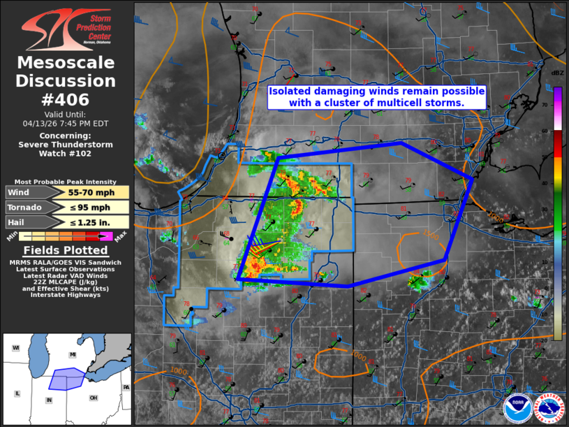
Mesoscale Discussion 0406 NWS Storm Prediction Center Norman OK 0509 PM CDT Mon Apr 13 2026 Areas affected...Northeast Indiana...far southern Lower Michigan...northwest Ohio Concerning...Severe Thunderstorm Watch 102... Valid 132209Z - 132345Z The severe weather threat for Severe Thunderstorm Watch 102 continues. SUMMARY...A multicell cluster of storms may produce occasional wind damage into early evening. Local extension in area of WW 102 is possible, but additional watches are not expected. DISCUSSION...A cluster of multicell storms continues east near the Indiana/Michigan border. Recent observations show max convective gusts in the low 40 kt range. Water vapor imagery shows modest shortwave ridging over this area which has lead to marginal effective shear values. Downstream of this activity, dewpoints have mixed down into the upper 50s F. The current expectation is for this cluster to continue to produce occasional damaging winds with a general decrease in intensity/organization with time. The strongest activity may remain on the southern flank where dewpoints are slightly higher. While local extensions of WW 102 may occur, additional watches are not expected at this time. ..Wendt.. 04/13/2026 ...Please see www.spc.noaa.gov for graphic product... ATTN...WFO...CLE...DTX...IWX...GRR... LAT...LON 41008620 42118572 42268421 41928333 41188369 40938487 41008620 MOST PROBABLE PEAK TORNADO INTENSITY...UP TO 95 MPH MOST PROBABLE PEAK WIND GUST...55-70 MPH MOST PROBABLE PEAK HAIL SIZE...UP TO 1.25 IN |
|
|
Top/All Mesoscale Discussions/Forecast Products/Home |
|
Source link