| Mesoscale Discussion 403 | |
| < Previous MD | |

|
|
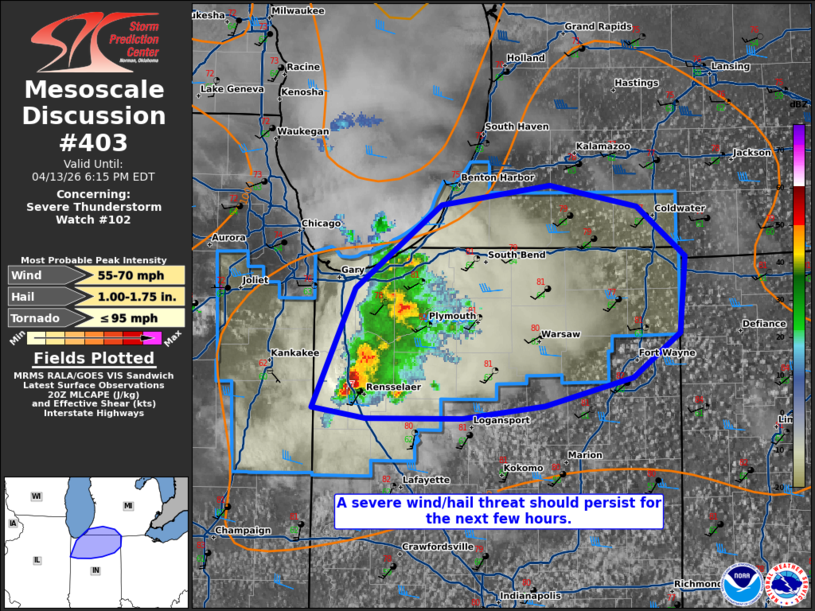
Mesoscale Discussion 0403 NWS Storm Prediction Center Norman OK 0338 PM CDT Mon Apr 13 2026 Areas affected...portions of northern Indiana into extreme southwestern Lower Michigan Concerning...Severe Thunderstorm Watch 102... Valid 132038Z - 132215Z The severe weather threat for Severe Thunderstorm Watch 102 continues. SUMMARY...A severe wind/hail threat should continue with ongoing storms over the next few hours. DISCUSSION...A multicellular cluster of thunderstorms is persisting eastward amid a heated boundary layer (characterized by surface temperatures over 80 F), and modest vertical wind shear. Multiple wind damage reports, along with measured gusts around 50 kts have been received over the past few hours. MRMS MESH has also indicated the possibility of 1+ inch hail occurring with some of the stronger storms as well. Given 60+ F surface dewpoints and resultant 1500+ J/kg MLCAPE preceding the storms, a severe wind/hail threat should continue with these storms for at least a few more hours. Given adequate surface-based instability preceding supercell structures, a tornado cannot be completely ruled out. ..Squitieri.. 04/13/2026 ...Please see www.spc.noaa.gov for graphic product... ATTN...WFO...IWX...GRR...LOT... LAT...LON 40868754 41528721 42008657 42108576 41988511 41708475 41278480 41028514 40878580 40798641 40798713 40868754 MOST PROBABLE PEAK TORNADO INTENSITY...UP TO 95 MPH MOST PROBABLE PEAK WIND GUST...55-70 MPH MOST PROBABLE PEAK HAIL SIZE...1.00-1.75 IN |
|
|
Top/All Mesoscale Discussions/Forecast Products/Home |
|
Source link