| Mesoscale Discussion 389 | |
| < Previous MD | |

|
|
Mesoscale Discussion 0389
NWS Storm Prediction Center Norman OK
0219 PM CDT Sun Apr 12 2026
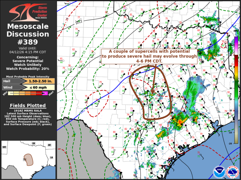
Areas affected...parts of central Texas
Concerning...Severe potential...Watch unlikely
Valid 121919Z - 122115Z
Probability of Watch Issuance...20 percent
SUMMARY...A couple of severe storms with potential to produce severe
hail may gradually develop through 4-6 PM CDT. It is not yet clear
that a severe weather watch will be needed, but trends will continue
to be monitored for this possibility.
DISCUSSION...Beneath the belt of 40-50 kt southwesterly 500 mb flow
overspreading central Texas, deepening convective development is
evident near and west of the I-35 corridor, from the Hill Country
northward into areas just southwest of the Metroplex. Forcing for
ascent downstream of a jet streak embedded within this regime may be
aiding development, which appears focused within weak
lower/mid-tropospheric warm advection on the northern/northeastern
periphery of a plume of more strongly capping elevated mixed-layer
air.
Boundary-layer moisture characterized by surface dew points near 70F
appears to be contributing to CAPE in excess of 1500 J/kg, aided by
increasing insolation in the wake of early day convection spreading
northeast and east of the region. Given the strong deep-layer
shear, it appears that a couple of supercell structures with
potential to produce large hail may develop as scattered storms
initiate over the next few hours.
..Kerr/Mosier.. 04/12/2026
...Please see www.spc.noaa.gov for graphic product...
ATTN...WFO...FWD...EWX...SJT...
LAT...LON 32179832 31869743 30189706 29889828 30429844 31599911
32179832
MOST PROBABLE PEAK WIND GUST...UP TO 60 MPH
MOST PROBABLE PEAK HAIL SIZE...1.50-2.50 IN
|
|
|
Top/All Mesoscale Discussions/Forecast Products/Home |
|
Source link