| Mesoscale Discussion 376 | |
| < Previous MD | |
|
|
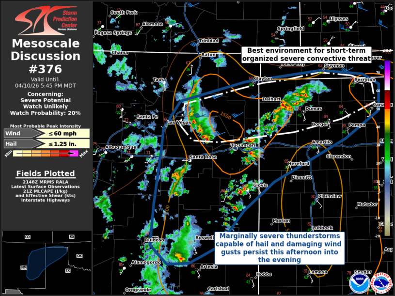
   Mesoscale Discussion 0376
   NWS Storm Prediction Center Norman OK
   0451 PM CDT Fri Apr 10 2026

   Areas affected...Eastern New Mexico into the Texas/Oklahoma
   Panhandles

   Concerning...Severe potential...Watch unlikely

   Valid 102151Z - 102345Z

   Probability of Watch Issuance...20 percent

   SUMMARY...Marginally severe thunderstorms across portions of eastern
   New Mexico into the Texas and Oklahoma Panhandles will persist late
   this afternoon into the evening hours. These storms will primarily
   be capable of damaging wind gusts and 1.00-1.25 inch hail. No
   weather watch issuance is anticipated at this time.

   DISCUSSION...Thunderstorms have developed in the vicinity and south
   of a surface cold front currently oriented east-west across portions
   of the Oklahoma and Texas Panhandles. Storms along and immediately
   south of the boundary will have support for at least some convective
   organization due to modest deep-layer shear of 35-40 kts, while
   further to the south and into eastern New Mexico, storms have
   primarily developed in deep/dry boundary layers with steep low-level
   lapse rates. All storms will be capable of some severe wind gusts
   and 1.00-1.25 in hail, with the greatest threat for organized severe
   storms being along and immediately south of the surface cold front.
   Thunderstorms in the deep/dry boundary layers further south are more
   likely to remain disorganized, but are capable of downbursts owing
   to the steep low-level lapse rates and tall LCL heights in excess of
   2 km. No WW issuance is anticipated at this time.

   ..Halbert/Thompson.. 04/10/2026

   ...Please see www.spc.noaa.gov for graphic product...

   ATTN...WFO...LUB...AMA...MAF...ABQ...EPZ...

   LAT...LON   35130532 35530527 36070488 36450336 36650154 36560058
               36370020 35860023 35340101 34520268 33970339 33270399
               32970463 32940513 33290552 33700550 34060547 35130532

   MOST PROBABLE PEAK WIND GUST...UP TO 60 MPH
   MOST PROBABLE PEAK HAIL SIZE...UP TO 1.25 IN
|
|
|
Top/All Mesoscale Discussions/Forecast Products/Home |
|
Source link