|
|
| Mesoscale Discussion 364 | |
| < Previous MD | |
|
|
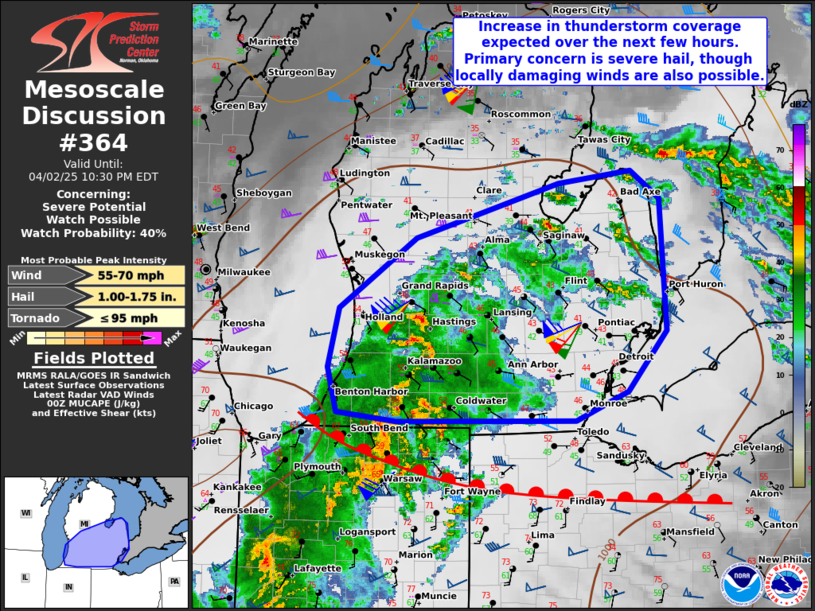
   Mesoscale Discussion 0364
   NWS Storm Prediction Center Norman OK
   0726 PM CDT Wed Apr 02 2025

   Areas affected...Portions of Lower Michigan

   Concerning...Severe potential...Watch possible

   Valid 030026Z - 030230Z

   Probability of Watch Issuance...40 percent

   SUMMARY...Thunderstorms should increase in coverage across portions
   of Lower Michigan during the next few hours. The primary concern
   would be isolated severe hail, though locally damaging gusts cannot
   be entirely ruled out.

   DISCUSSION...The latest VWP data from DTX/GRR shows a strengthening
   low-level jet and associated warm advection overspreading Lower MI
   -- to the north of an east/west-oriented warm front across northern
   IN/OH. This will favor an increase in thunderstorm coverage over the
   next few hours. The DTX 00Z soundings sampled an environment
   marginally supportive of elevated supercell structures embedded
   within increasing stratiform rain (around 55 kt of effective shear).
   However, marginal elevated buoyancy (880 J/kg MUCAPE) may limit
   updraft intensity to an extent. Nevertheless, the risk of isolated
   severe hail (around 1 inch) should increase during the next few
   hours, and locally damaging winds cannot be entirely ruled out with
   any established supercells -- especially farther south closer to the
   warm front.

   ..Weinman/Hart.. 04/03/2025

   ...Please see www.spc.noaa.gov for graphic product...

   ATTN...WFO...DTX...IWX...GRR...

   LAT...LON   41818567 41888640 42298652 42818638 43448545 43948373
               44058285 43808250 42628242 42088289 41818352 41818567

   MOST PROBABLE PEAK TORNADO INTENSITY...UP TO 95 MPH
   MOST PROBABLE PEAK WIND GUST...55-70 MPH
   MOST PROBABLE PEAK HAIL SIZE...1.00-1.75 IN
|
|
|
Top/All Mesoscale Discussions/Forecast Products/Home |
|
Source link