| Mesoscale Discussion 36 | |
| < Previous MD Next MD > | |

|
|
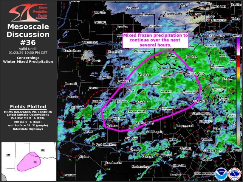
   Mesoscale Discussion 0036
   NWS Storm Prediction Center Norman OK
   0630 PM CST Fri Jan 23 2026

   Areas affected...portions of Southwest Texas

   Concerning...Winter mixed precipitation

   Valid 240030Z - 240430Z

   SUMMARY...A mix of wintry precipitation will continue across
   portions of southwestern and west-central Texas through the next
   several hours.

   DISCUSSION...Surface observations across southwestern Texas into
   west-central Texas are showing a variety of wintry precipitation
   types from light snow into the Panhandle to a mix of sleet/freezing
   rain closer to the I-20 corridor. 00z sounding data from Amarillo
   shows a weakening warm nose above 850mb, which supports the
   transition to mostly snow across the Panhandle.

   RAP forecast soundings along and south of the Red River and along
   and north of I-20 continue to show a pronounced warm nose around
   850-700 mb through much of the evening into tomorrow morning. This
   warmer air atop sub-freezing surface temperatures will support a
   predominate precipitation type of mostly light to moderate sleet and
   occasional light snow north of I-20, with a transition to light
   freezing rain along and south of I-20 where a deeper layer of warm
   air aloft resides.

   ..Thornton.. 01/24/2026

   ...Please see www.spc.noaa.gov for graphic product...

   ATTN...WFO...FWD...OUN...SJT...LUB...AMA...MAF...

   LAT...LON   32430265 33110200 34130103 34630035 34939957 34939903
               34159817 33829790 33499772 32869778 32509840 32199934
               31920027 31660094 31550168 31730243 32430265
|
|
|
Top/All Mesoscale Discussions/Forecast Products/Home |
|
Source link