| Mesoscale Discussion 320 | |
| < Previous MD Next MD > | |

|
|
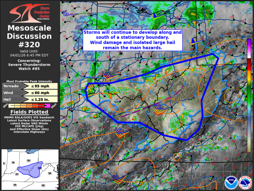
Mesoscale Discussion 0320 NWS Storm Prediction Center Norman OK 0340 PM CDT Wed Apr 01 2026 Areas affected...Parts of middle/upper Ohio Valley Concerning...Severe Thunderstorm Watch 85... Valid 012040Z - 012245Z The severe weather threat for Severe Thunderstorm Watch 85 continues. SUMMARY...Convection should continue along the stationary boundary and near outflow from earlier storms. Isolated large hail and wind damage are the main hazards with this activity. DISCUSSION...A majority of the activity within WW 85 remains near and south of a stationary front north of the Ohio River. An additional cluster persists in southern West Virginia. Thus far, storms have maintained a primarily cellular mode and produce isolated large hail. The expectation for the remainder of the afternoon is for additional storms to move into the watch from the west as well as other storms potentially developing along outflow from storms in West Virginia. The cluster in southern West Virginia is likely to weaken as it moves into the terrain as temperatures there are slightly cooler and convection has influenced the airmass farther east. Regional VAD data shows 40-50 kts of 0-6 km shear which should continue to support organized storms capable of primarily isolated large hail and wind damage. ..Wendt.. 04/01/2026 ...Please see www.spc.noaa.gov for graphic product... ATTN...WFO...RNK...PBZ...RLX...JKL...ILN...LMK... LAT...LON 38288457 38558509 38888520 39108507 39128415 39438271 39668201 39958050 40077984 39927960 39068009 38568036 38068031 37638048 37278098 37468197 37858291 37868383 38288457 MOST PROBABLE PEAK TORNADO INTENSITY...UP TO 95 MPH MOST PROBABLE PEAK WIND GUST...UP TO 60 MPH MOST PROBABLE PEAK HAIL SIZE...UP TO 1.25 IN |
|
|
Top/All Mesoscale Discussions/Forecast Products/Home |
|
Source link