| Mesoscale Discussion 315 | |
| < Previous MD | |
|
|
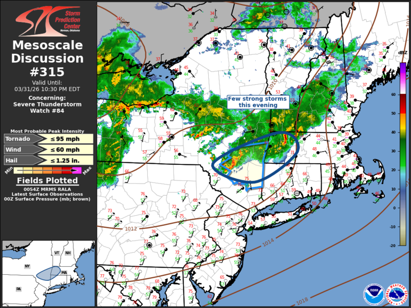
Mesoscale Discussion 0315 NWS Storm Prediction Center Norman OK 0756 PM CDT Tue Mar 31 2026 Areas affected...Lower Hudson Valley into northwest Connecticut and western Massachusetts Concerning...Severe Thunderstorm Watch 84... Valid 010056Z - 010230Z The severe weather threat for Severe Thunderstorm Watch 84 continues. SUMMARY...A few strong to locally severe thunderstorms will spread across the lower Hudson Valley into northwest CT and western MA over the next few hours. Gusty winds are the primary concern. DISCUSSION...Weak buoyancy has yet to be overturned across the lower Hudson Valley into western portions of southern New England where surface temperatures are holding in the lower 70s. Leading edge of long-lived complex of storms is spreading across this region but this activity appears to be slowly weakening as it advances downstream. Latest surface analysis depicts a sharp front is draped across RI into central MA where easterly low-level flow is maintaining surface temperatures in the 40s. Current thinking is a narrow corridor exists for robust convection over the next few hours and this activity will pose mostly a gusty wind risk. ..Darrow.. 04/01/2026 ...Please see www.spc.noaa.gov for graphic product... ATTN...WFO...BOX...ALY...BGM... LAT...LON 42037497 42717302 42307247 41627375 42037497 MOST PROBABLE PEAK TORNADO INTENSITY...UP TO 95 MPH MOST PROBABLE PEAK WIND GUST...UP TO 60 MPH MOST PROBABLE PEAK HAIL SIZE...UP TO 1.25 IN |
|
|
Top/All Mesoscale Discussions/Forecast Products/Home |
|
Source link