| Mesoscale Discussion 314 | |
| < Previous MD | |
|
|
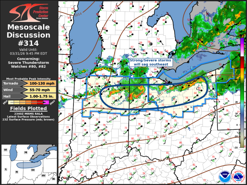
Mesoscale Discussion 0314 NWS Storm Prediction Center Norman OK 0642 PM CDT Tue Mar 31 2026 Areas affected...Ohio Valley Concerning...Severe Thunderstorm Watch 80...82... Valid 312342Z - 010145Z The severe weather threat for Severe Thunderstorm Watch 80, 82 continues. SUMMARY...Strong-severe thunderstorms will sag southeast this evening. DISCUSSION...Southern edge of stronger westerly flow extends across the OH Valley early this evening. Latest satellite imagery suggests several weak disturbances are advancing across the Great Lakes region with one feature noted over Lower MI/northern IN. This low-amplified short wave appears partly responsible for recent uptick in convection immediately downstream across northeast IN/northwest OH. Radar data suggests a a small MCS is evolving over northwest OH and a bow may be forming along the leading edge of this activity over Henry/Putnam County. Damaging winds may become more common with this maturing complex as it spreads across northwest into north central OH. ..Darrow.. 03/31/2026 ...Please see www.spc.noaa.gov for graphic product... ATTN...WFO...CLE...ILN...IWX... LAT...LON 41328597 41488247 41728118 41008113 40618302 40578567 41328597 MOST PROBABLE PEAK TORNADO INTENSITY...100-130 MPH MOST PROBABLE PEAK WIND GUST...55-70 MPH MOST PROBABLE PEAK HAIL SIZE...1.00-1.75 IN |
|
|
Top/All Mesoscale Discussions/Forecast Products/Home |
|
Source link