| Mesoscale Discussion 312 | |
| < Previous MD Next MD > | |
|
|
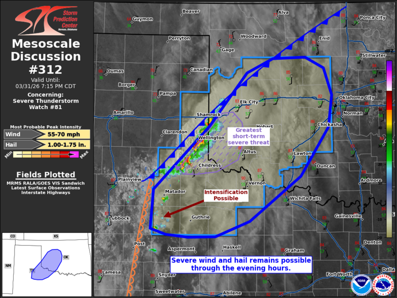
Mesoscale Discussion 0312 NWS Storm Prediction Center Norman OK 0552 PM CDT Tue Mar 31 2026 Areas affected...portions of northwestern Texas into western Oklahoma Concerning...Severe Thunderstorm Watch 81... Valid 312252Z - 010015Z The severe weather threat for Severe Thunderstorm Watch 81 continues. SUMMARY...Severe wind and hail remains possible with ongoing multicells and supercells along the TX Panhandle/OK border. Strong to potentially severe storms may also develop along the dryline in northwestern TX. DISCUSSION...Supercells and multicells along the surface cold front/dryline intersection persists along the eastern TX panhandle, and are moving into western OK. Current MRMS mesh depicts potential 1-2 inch diameter hail falling from these storms. These cells are also overspreading a surface airmass characterized by 30 T/Td spreads, suggesting that damaging gusts may also occur as well. While the greatest short-term severe potential exists with these storms, visible satellite and MRMS mosaic radar data indicates intensifying convection along the dryline across northwestern TX. If these storms can mature, steep tropospheric lapse rates will promote severe gust potential, perhaps accompanied by some hail. ..Squitieri.. 03/31/2026 ...Please see www.spc.noaa.gov for graphic product... ATTN...WFO...OUN...SJT...LUB...AMA... LAT...LON 34100101 35099998 35919926 36139878 36169816 35989780 35569766 35069772 34319826 33619922 33369985 33350037 33400078 33480106 34100101 MOST PROBABLE PEAK WIND GUST...55-70 MPH MOST PROBABLE PEAK HAIL SIZE...1.00-1.75 IN |
|
|
Top/All Mesoscale Discussions/Forecast Products/Home |
|
Source link