| Mesoscale Discussion 303 | |
| < Previous MD | |
|
|
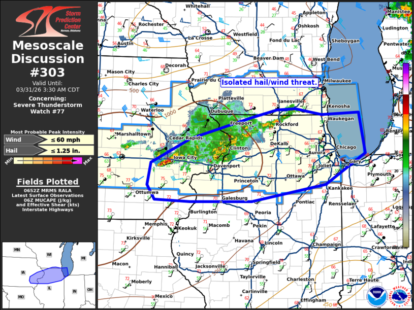
Mesoscale Discussion 0303 NWS Storm Prediction Center Norman OK 0154 AM CDT Tue Mar 31 2026 Areas affected...eastern Iowa and northern Illinois Concerning...Severe Thunderstorm Watch 77... Valid 310654Z - 310830Z The severe weather threat for Severe Thunderstorm Watch 77 continues. SUMMARY...An isolated large hail/wind threat remains. DISCUSSION...Storms which produced some large hail and damaging wind gusts earlier have now mostly weakened and congealed into a mass of mostly sub-severe storms. A few stronger cells, such as the one currently near Iowa City, may pose a isolated large hail/damaging wind threat. However, the overall threat appears to be waning. Therefore, given the remaining isolated/marginal threat, watch 77 will likely be allowed to expire at 08Z, even if an isolated threat may persist after this time. ..Bentley/Mosier.. 03/31/2026 ...Please see www.spc.noaa.gov for graphic product... ATTN...WFO...LOT...ILX...MKX...DVN... LAT...LON 41629204 42079109 42468961 42588903 42608860 42508796 42538707 41798692 41248787 40958963 40949110 40979194 41239211 41629204 MOST PROBABLE PEAK WIND GUST...UP TO 60 MPH MOST PROBABLE PEAK HAIL SIZE...UP TO 1.25 IN |
|
|
Top/All Mesoscale Discussions/Forecast Products/Home |
|
Source link