| Mesoscale Discussion 300 | |
| < Previous MD | |
|
|
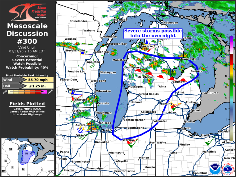
   Mesoscale Discussion 0300
   NWS Storm Prediction Center Norman OK
   1049 PM CDT Mon Mar 30 2026

   Areas affected...Lower Michigan and far northern Indiana

   Concerning...Severe potential...Watch possible

   Valid 310349Z - 310615Z

   Probability of Watch Issuance...40 percent

   SUMMARY...Isolated severe storms mainly capable of hail should
   increase through late evening into the overnight. While the need for
   a Watch is uncertain, short-term trends will continue to be
   monitored.

   DISCUSSION...Thunderstorms have steadily increased through late
   evening across the middle part of Lower Michigan. These storms are
   occurring near/just north of a stationary/slow-moving warm front,
   and should further increase over the next several hours via
   warm/moist advection and isentropic ascent. Additional storm
   development/persistence may also occur farther south across southern
   Lower Michigan and far northern Indiana via storms that are
   developing across northeast Illinois. Steep mid-level lapse rates
   are steadily advecting eastward across the region, and strong shear
   through the cloud-bearing layer will support some severe
   storms/elevated supercells north of the front. Some damaging wind
   potential may also exist with any storm development or persistence
   into/across the southern half of Lower Michigan and/or far northern
   Indiana, although increasing convective inhibition will tend to be a
   detrimental factor.

   ..Guyer.. 03/31/2026

   ...Please see www.spc.noaa.gov for graphic product...

   ATTN...WFO...DTX...APX...IWX...GRR...LOT...

   LAT...LON   44608628 44408444 44318308 43728255 43078393 41908473
               41398595 41498695 43208655 44608628

   MOST PROBABLE PEAK WIND GUST...55-70 MPH
   MOST PROBABLE PEAK HAIL SIZE...UP TO 1.25 IN
|
|
|
Top/All Mesoscale Discussions/Forecast Products/Home |
|
Source link