| Mesoscale Discussion 298 | |
| < Previous MD | |

|
|
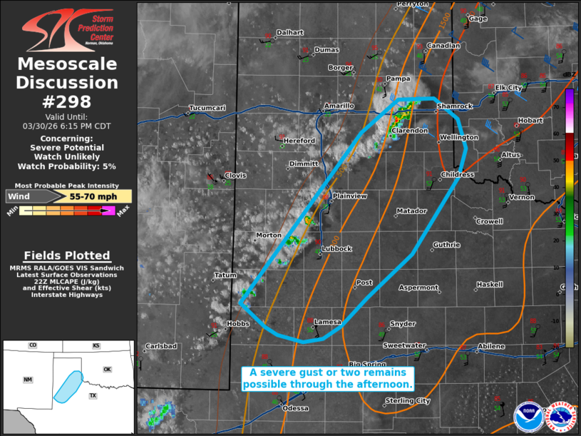
   Mesoscale Discussion 0298
   NWS Storm Prediction Center Norman OK
   0519 PM CDT Mon Mar 30 2026

   Areas affected...portions of the Texas Panhandle

   Concerning...Severe potential...Watch unlikely

   Valid 302219Z - 302315Z

   Probability of Watch Issuance...5 percent

   SUMMARY...A severe gust or two remains possible with high-based
   storms through the remainder of the afternoon.

   DISCUSSION...High-based multicellular storms have intensified over
   portions of the eastern TX panhandle over the past couple of hours,
   with a severe gust recently noted via the Goodnight, TX mesonet.
   Furthermore, there are hints of convective intensification along a
   diffuse dryline. These storms are all progressing eastward atop a
   deep boundary layer (mixed up to 600 mb per latest RAP forecast
   soundings). Given poor shear amid MLCAPE under 500 J/kg, the severe
   threat should remain sparse, though a severe gust or two remains
   possible given the mixed boundary layer in place.

   ..Squitieri/Guyer.. 03/30/2026

   ...Please see www.spc.noaa.gov for graphic product...

   ATTN...WFO...OUN...LUB...AMA...MAF...

   LAT...LON   33000293 34970129 35350077 35360027 35129994 34779982
               34449993 33570059 33060120 32730157 32590181 32560208
               32640243 32730259 33000293

   MOST PROBABLE PEAK WIND GUST...55-70 MPH
|
|
|
Top/All Mesoscale Discussions/Forecast Products/Home |
|
Source link