| Mesoscale Discussion 294 | |
| < Previous MD Next MD > | |
|
|
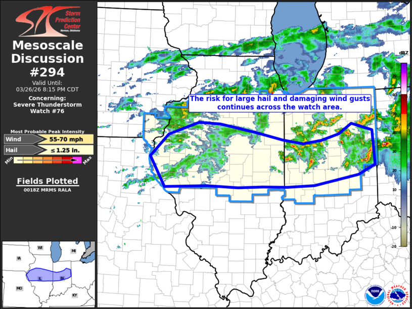
Mesoscale Discussion 0294 NWS Storm Prediction Center Norman OK 0721 PM CDT Thu Mar 26 2026 Areas affected...Central portions of Illinois and Indiana Concerning...Severe Thunderstorm Watch 76... Valid 270021Z - 270115Z The severe weather threat for Severe Thunderstorm Watch 76 continues. SUMMARY...The risk for large hail and damaging winds continues across the watch area. DISCUSSION...A south/southeast-moving cold front extended across central portions of IN/IL at 00z, with scattered strong/severe storms located in the vicinity of the front, primarily across the IN portion of the watch. These storms have a history of wind damage and large hail up to the size of golfballs. The downstream environment will remain favorable for a continued severe threat through 03-04z with upwards of 1000 J/kg MLCAPE and sufficient shear for organized storms. Farther west, some increase in reflectivity has been noted with convective elements along the front over far west-central IL. High-res guidance, notably recent runs of the HRRR, suggests that additional thunderstorm development will be possible over the next couple of hours, with some severe hail/wind threat accompanying the strongest storms. ..Bunting.. 03/27/2026 ...Please see www.spc.noaa.gov for graphic product... ATTN...WFO...ILN...IWX...IND...LOT...ILX...LSX...DVN... LAT...LON 40719094 40989005 40958942 40768835 40608756 40518696 40578643 40728591 40948553 40798491 40018485 39798536 39568665 39528745 39538816 39518889 39568979 39519103 40219147 40719094 MOST PROBABLE PEAK WIND GUST...55-70 MPH MOST PROBABLE PEAK HAIL SIZE...UP TO 1.25 IN |
|
|
Top/All Mesoscale Discussions/Forecast Products/Home |
|
Source link