| Mesoscale Discussion 293 | |
| < Previous MD | |

|
|
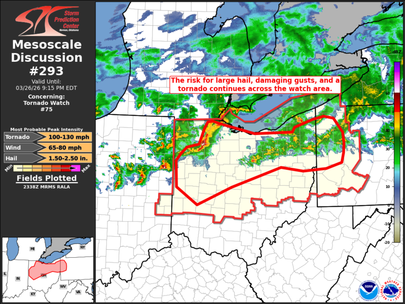
Mesoscale Discussion 0293 NWS Storm Prediction Center Norman OK 0640 PM CDT Thu Mar 26 2026 Areas affected...portions of northern and central Ohio...western Pennsylvania Concerning...Tornado Watch 75... Valid 262340Z - 270115Z The severe weather threat for Tornado Watch 75 continues. SUMMARY...The risk for large hail, damaging gusts, and a tornado continues in advance of a cold front moving southeast across the watch area this evening. DISCUSSION...A cold front was located over far northern OH and northwest PA at 2330z, with a line segment of severe thunderstorms moving southeast across northwest OH extending from near Toledo to Ottawa and a history of damaging winds and severe hail. In the presence of MLCAPE of 500 to locally 1000 J/kg and sufficient deep-layer shear, the environment will favor supercell and linear structures capable of continued potential for large hail and damaging gusts. Low-level shear of 150-200 m2/s2 will support some potential for low-level rotation and a risk for a tornado, especially with any semi-discrete storm that can persist. Severe storms moving into western OH west of Versailles will likely continue to pose a severe risk given the favorable thermodynamic and kinematic environment, and local watch extension has been coordinated in this area. Across eastern OH/western PA, more isolated severe storms have developed and occasionally exhibited supercell characteristics. Latest RAP soundings suggest a continued favorable environment for severe wind and hail, along with the potential for a tornado given sufficient low-level shear. ..Bunting.. 03/26/2026 ...Please see www.spc.noaa.gov for graphic product... ATTN...WFO...PBZ...CLE...ILN...IWX... LAT...LON 41078439 41158404 41478389 41668379 41678364 41608331 41398236 41438122 41538116 41718062 41788027 41727998 41407971 41147968 40947969 40727975 40598022 40548091 40628158 40188305 39768407 40168469 40778471 40928457 41078439 MOST PROBABLE PEAK TORNADO INTENSITY...100-130 MPH MOST PROBABLE PEAK WIND GUST...65-80 MPH MOST PROBABLE PEAK HAIL SIZE...1.50-2.50 IN |
|
|
Top/All Mesoscale Discussions/Forecast Products/Home |
|
Source link